Helicopter flying around is for airborne survey
The Addie has received numerous phone calls from curious residents as to what the helicopter “with the lines” has been doing for the past few weeks.
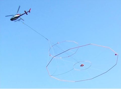
The Council for Geoscience has undertaken an airborne geophysical survey over an area covering parts of Boksburg, Benoni, Brakpan, Springs, Welgedacht, Grootvaly, Daggafontein, Endicott, Nigel and Ferryvale.
The survey began in June and will continue until August.
During the survey, a specially equipped helicopter will be seen flying at low level over the designated area, but avoiding built-up areas.
An electromagnetic survey sensing unit will be slung underneath the helicopter.
The survey is part of a process whereby the council is mapping water lines along these areas to establish where the underground water lines lead to.
More in-depth information will follow as soon as we receive response from the Council for Geoscience.
Connect with us:
Do you have an interesting newsworthy story? Contact the newsroom on 011 812 4800 or send an email to Samantha Keogh (editor) samk@caxton.co.za, Izahn Krige (digital journalist) izahnv@caxton.co.za or Anna Robertson (journalist) annar@caxton.co.za
For the latest breaking news in your community, follow us on Twitter @SpringsNews and like our Facebook page.
For news straight to your phone and daily weather updates, invite Springs Advertiser on WhatsApp by sending a message with your name and surname to 079 408 9334.
To see what we get up to in the newsroom and in town, follow us on Instagram at springs_addie