Level 6 warning issued as heavy storms set to hit Gauteng
The South African Weather Service has issued multiple weather warnings for Gauteng and Mpumalanga this weekend heading into Monday.
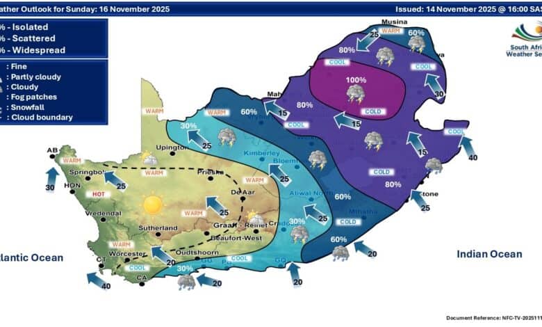
Residents across Gauteng should prepare for a wet and stormy weekend, with the South African Weather Service (SAWS) issuing multiple impact-based warnings for Saturday through Monday.
According to SAWS, scattered to widespread showers and thundershowers are expected across the province from Saturday, intensifying into Sunday, November 16 and Monday, November 17.
Severe weather expected
For Sunday, SAWS has issued an Orange Level 6 warning for severe thunderstorms over Gauteng, the western Highveld of Mpumalanga.
These storms may lead to flooding of roads, low-lying areas, and bridges.
Also read: EMPD weekly tip: driving in wet weather
A Yellow Level 2 warning for severe thunderstorms is also in place for parts of Gauteng on Monday, with the potential for localised flooding, lightning, hail, and strong winds.
The extended outlook for Gauteng includes:
- Scattered to widespread showers and thundershowers, especially in the east.
- Heavy downpours may cause reduced visibility and difficult driving conditions.
- Possible damage to property, roads, and electrical infrastructure.
Saturday Alerts
While Gauteng’s highest alert comes on Sunday, parts of the province fall under a Yellow Level 2 warning for Saturday, November 15.
This includes risks of localised flooding of roads and low-lying areas, isolated infrastructure damage and potential livestock losses.
Also read: Tips for protecting your assets during natural disasters and severe weather
Extended weather forecast for Sunday and Monday, 16-17 November:
Scattered to widespread showers and thundershowers are expected in the east.
⚠️Orange level 6 warning: Severe thunderstorms.
⚠️Yellow level 4 warning: Disruptive rain.
⚠️Yellow level 2 warning: Severe thunderstorms. pic.twitter.com/za7rJ8F1so— SA Weather Service (@SAWeatherServic) November 14, 2025
Gauteng forecasts
- Pretoria: Partly cloudy in the morning, turning cloudy with evening showers and thunderstorms. 16° / 26°
- Johannesburg: Morning cloud, becoming cloudy with evening thunderstorms. 15° / 24°
- Vereeniging: Cloud building into the afternoon with evening thunderstorms. 15° / 25°
Safety tips: Driving in wet weather
- Reduce speed and keep a safe following distance.
- Turn on headlights for visibility, even during the day.
- Never cross flooded roads, bridges, or low-lying areas.
- Avoid distractions and keep both hands on the wheel in strong winds.
- Be alert for potholes, debris, and slippery road surfaces.
- Pull over safely if visibility becomes too poor.
Residents are encouraged to monitor updates from SAWS and local authorities throughout the weekend.
Elsewhere in the country
Widespread showers and thundershowers are forecast for the North West, Free State and parts of the Northern Cape, while KwaZulu-Natal can expect heavy rainfall and possible disruptions.
The Western Cape will experience mainly dry conditions with a fresh southeaster along the coast, but an extremely high fire danger warning has been issued for Bergrivier, Swartland and Matzikama.