Heavy weather warning for KZN
While all eyes are on intense tropical cyclone Batsirai, the heavy weather forecast for this weekend is courtesy of a low pressure system moving up from the south
The South African Weather Service (SAWS) has issued a level 4 warning for disruptive rain, set to affect most parts of northern KZN.
‘Disruptive rain leading to localised flooding, displacement of affected communities and poor driving conditions is expected over some parts of KZN today,’ said SAWS earlier this (Friday) morning.
SAWS said a ‘significant amount’ of rainfall is expected.
The impact of the heavy rains could include possible damage to roads and bridges.
Areas set to be affected are Hluhluwe, Jozini, Mandeni, Mthonjaneni, Mtubatuba, uMhlabuyalingana, uMhlathuze and uMlalazi.
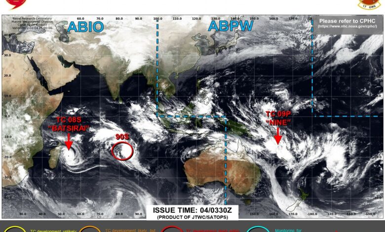
Batsirai latest
While all eyes are on intense tropical cyclone Batsirai, the heavy weather forecast for this weekend is courtesy of a low pressure system moving up from the south.
Batsirai made landfall on Mauritius earlier in the week and is expected to make landfall on Madagascar tomorrow evening.
As of 5am today, Batsirai was located 191km northwest of St Denis on the island of Reunion, having moved at a slow rate of 11km/h over the previous six hours.
According to the Joint Typhoon Warning Centre (JTWC), Batsirai will continue tracking west-southwest under the influence of the subtropical ridge until making landfall on Madagascar.
After making landfall on Madagascar tomorrow, the system will continue tracking west-southwest across the island and enter the Mozambican Channel in about three days.
As with all tropical cyclones, Batsirai will lose a lot of its power once making contact with the Madagascar landmass.
‘Batsirai is expected to slightly intensify to 205km/h (110 knots) in around 12 hours as the eye wall continues to constrict, and then decrease to 185km/h (100 knots) at 36 hours as the western portion of the wind field begins to interact with land,’ said JTWC.
‘The system will decrease to 85km/h (45 knots) as it crosses over land, and reintensify in the
Mozambique Channel, reaching 100km/h (55 knots) in 4 days.’
It is still too early for weather experts to forecast what impact, if any, Batsirai will have on South Africa.