Expect heavy rain from Sunday, experts warn
Expected heavy rain from Sunday to Wednesday is a threat to motorists and the public during the end of the festive season – South African Weather Service.
The South African Weather Service (SAWS) is alerting motorists returning to economic activities, pedestrians and the public to be aware of heavy, disruptive rain across the central and eastern regions of South Africa from this Sunday to at least Wednesday (5 to 8 January).
The expected persistent rainfall, with associated risks, emphasised the need for caution and preparedness among all road users and the public.
• ALSO READ: ‘Tis the rainy season: How to keep your car, home contents safe
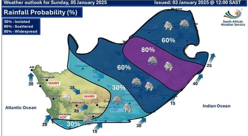
Scattered (60%) and widespread (80%) showers and thundershowers are expected on Sunday across the central and eastern regions of South Africa, as can be seen in Figure 1 below. These regions include North West, the Free State, KwaZulu-Natal and the southern parts of Mpumalanga and Gauteng.
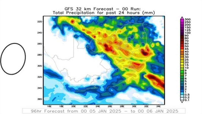
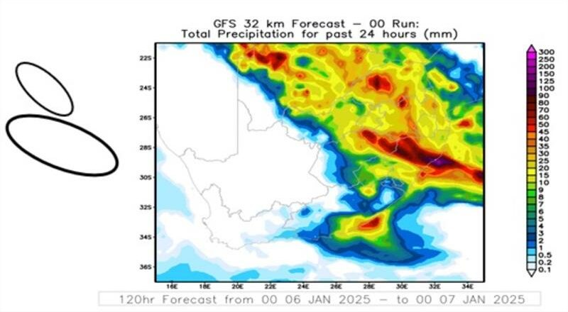
The likelihood of a significant increase in rainfall accumulation is suggested, with amounts ranging from 50 to 70 mm (see output of weather model in Figure 2). To this effect, road flooding, slippery surfaces, and broad flash flooding are possible. The use of vehicle headlights, while driving at a reasonably low speed, will be useful during the showery conditions.
Motorists should ensure clear windscreens, as traffic and road markings could be difficult to see during the occurrence of heavy rain, even for vehicles with properly working wipers, in some instances. Further, some low-water bridges could inevitably overflow, with powerful water currents that could sweep away vehicles and lead to loss of lives and property. It is strongly advised that motorists do not enter flooded low-water bridges or roads.
Usually, summer thundershowers are confined to the afternoon and early evening hours. However, the continuous flow of warm moist air (tropical moisture) to South Africa from countries to the north is expected to cause showers at any time of the day. This means that ordinary or even heavy showers could be expected between 18:00 and 01:00 in the early morning.
According to the Road Traffic Management Centre (RTMC), these are the critical hours that road users should avoid driving. For this festive season, a higher number of road fatalities than in previous years has already been reported, and the SAWS, in collaboration with the RTMC, would like to urge motorists, pedestrians and the public to be extra vigilant and careful on the roads during these conditions to prevent the further loss of lives.
The rainfall distribution is anticipated to remain scattered to widespread across the central and eastern regions of the country on Monday, 6 January 2025, as reflected in Figure 3.
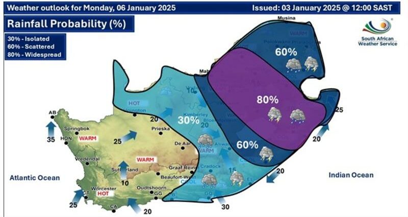
These conditions will most likely be accompanied by the persistence of disruptive rain and localised flooding across North West, the Free State, Gauteng as well as the western Bushveld of Limpopo, Mpumalanga, and KwaZulu-Natal, as shown in Figure 4. These adverse weather conditions are expected to persist until January 8 over the north-eastern and eastern provinces, where potential flooding can be expected as a result of the persistent rainfall.
Incidents of heavy rain are expected across the eastern regions of the Republic towards midweek, although clearance is on the cards across the central region. Vigilant and safe driving should remain in force.
The summer rainfall areas of South Africa have been significantly impacted by heavy rainfall throughout December 2024, resulting in flooding and localised structural and infrastructural damage.
Given the potential impacts from this Sunday to at least Wednesday, it is crucially important for the public to stay informed by monitoring weather warnings and updates from the SAWS. Such weather warnings are updated daily and can be accessed on the SAWS website here and from broadcasts on local media and television channels.
Furthermore, intermediate updates may be followed on X (@SAWeatherServic) or Facebook (South African Weather Service).
To ensure safety and preparedness, the following precautions are advised:
• Avoid crossing flooded roads or swollen streams.
• Move to higher ground if rising water levels are observed.
• Refrain from travelling on bridges or roads in low-lying areas, which are particularly vulnerable to flooding.
According to SAWS, adherence to these guidelines can significantly reduce risks and help ensure public safety during this period of adverse weather conditions.