Level 4 storm alert for Tzaneen, Phalaborwa and Hoedspruit areas
The SA Weather Service warns of severe thunderstorms across Tzaneen, Phalaborwa and Hoedspruit from Monday afternoon into Tuesday morning.

TZANEEN – Residents in the Tzaneen, Phalaborwa and Hoedspruit areas have been urged to take caution as the South African Weather Service (SAWS) has issued a Level 4 severe thunderstorm warning in effect from 13:00 today (October 27) until 06:59 tomorrow morning (October 28).
According to the SAWS, the warning carries a low likelihood but potentially high impact, as intense thundershowers are expected to develop this afternoon and persist overnight across much of the Mopani district.
“Thundershowers are expected to develop this afternoon and have the potential of becoming severe over vast parts of Limpopo and Mpumalanga,” the SAWS statement reads.
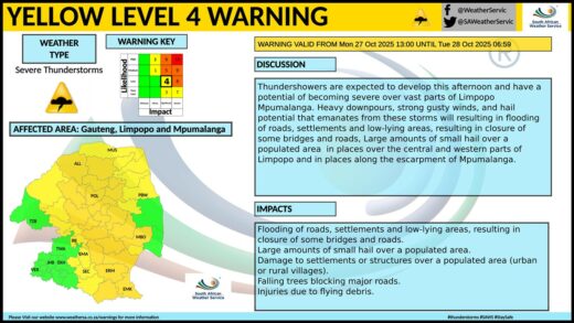
The weather service has cautioned that the storms could bring heavy downpours, strong gusty winds and hail, which may lead to flooding of roads, low-lying areas and informal settlements.
Residents in affected areas are advised to stay indoors where possible, avoid travelling during storm activity, and not cross flooded rivers or causeways.
More rain expected through the week
Forecasters say more rain and scattered thundershowers are expected over Tzaneen, Phalaborwa and Hoedspruit in the days ahead, with isolated storms likely to continue through midweek.
Daytime temperatures are expected to remain mild to warm, ranging between 24°C and 35°C, with partly cloudy to overcast conditions persisting into the weekend.