
Look: Parts of SA blanketed in snow as cold front heads for Gauteng
Snowfall has turned parts of South Africa into a winter wonderland as cold fronts bring an unseasonable chill.
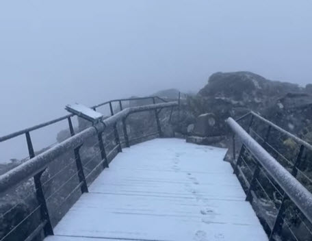
Two cold fronts will impact Gauteng later this week, bringing much cooler weather, while snow has already been reported on Table Mountain.
According to VoxWeather forecaster Michelle Cordier, temperatures in Gauteng will drop from tomorrow, with highs in the low 20s and lows between 10°C and 15°C.
“The weather will be mostly cloudy, and there could be light rain.”
This is because significant snowfall is expected in parts of South Africa this week.
Heavy snowfall was confirmed in several parts of the country by today, including snow on Table Mountain.
Look at these photos and videos:
Cape Town – SNOW on Table Mountain pic.twitter.com/6QvcqWCxHg
— TrafficSA (@TrafficSA) August 28, 2024
Hectic. There is a icy chill in the Vape Town air and this is the reason. Table Mountain snow fest. pic.twitter.com/t74ZvxcmQ9
— Garth Breytenbach (@poormanscaviar) August 28, 2024
Wish I could’ve been on Table Mountain to see the snow. But my view from below isn’t bad either. Cape Town 💙❄️ pic.twitter.com/Y9J9McjQSS
— Ulrich Janse van Vuuren (@UlrichJvV) August 28, 2024
❄️LATEST SNOW FORECAST | 27 – 30 Aug 2024 ❄️
TWO COLD FRONTS & a RIDGING HIGH PRESSURE system will bring COLD,WET & WINDY weather to the south-west this week & also drop FREEZING LEVELS low enough for SNOW from Tuesday evening!
‼ STAY WARM SOUTH AFRICA‼#VoxWeather #Snowinsa pic.twitter.com/qWKKM0hdKW
— Vox Weather (@VoxWeatherZa) August 26, 2024
By Friday, Gauteng will experience even colder conditions, with temperatures below 20°C and lows dipping below 10°C.
“The cold, cloudy, and rainy weather will persist throughout the day. While snow is expected in other regions, Gauteng will mainly see chilly, wet conditions. The temperatures are expected to warm up again by Sunday.”
Cordier said two cold fronts and a ridging high-pressure system will bring cold, wet, and windy weather to the south-western parts of South Africa this week and also drop temperature levels low enough for widespread snow from Tuesday evening.
“Both the Global Forecast System and the European weather model are showing significant snowfall from Tuesday evening over the mountain peaks in the Western Cape (Matroosberg Nature Reserve, Cederberg, and Swartberg mountain range_ and Northern Cape (Nuweland and Roggeveld mountain) including the town of Sutherland.”
Meanwhile, a light dusting of snow is also possible over the Hottentots Holland Mountains and Boland Mountains in the Western Cape.
Cordier said snow will continue to fall over the mountains in the Western Cape (Matroosberg Nature Reserve and Cederberg Mountains), with ground snow possibly occurring in towns like Sutherland in the Karoo.
Read original story on www.citizen.co.za