
Wet weather as tropical storm approaches
Scattered thundershowers are expected to develop mainly this afternoon
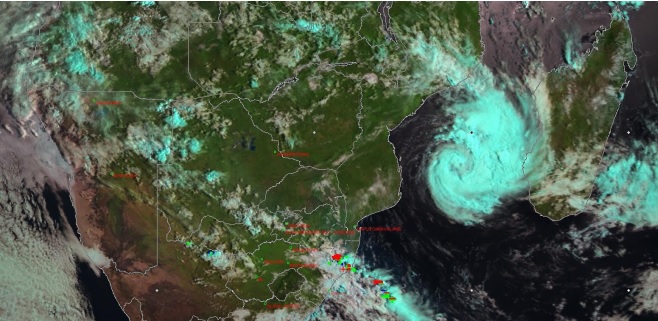
The South African Weather Services has confirmed in an update that Tropical Storm Dineo is expected to reach cyclone status early tomorrow morning (Wednesday).
The Regional Specialised Meteorological Centre (RSMC) La Reunion has updated the expected evolution of the tropical storm which is now expected to reach winds of up to 118-165km/h.
Further intensification is expected and the storm will reach the Intense Tropical Cyclone (winds of up to 166-212 km/h) around midday tomorrow, before making landfall at midnight near Inhambane in southern Mozambique.
South Africa will only start to experience the rain from this tropical system on Thursday over the Lowveld, spreading westwards by Friday.
Over South Africa today, scattered thundershowers are expected to develop mainly this afternoon over the central, south-eastern and eastern parts with heavier showers possible over the south-eastern parts of Mpumalanga and northern parts of KZN.
>>> Meet the top players in the North Coast property industry. See our Property People feature.
>>> Looking for a church? Check out our Churches on the North Coast feature.
Do you want to receive news alerts via WhatsApp? Send us a WhatsApp message (not an sms) with your name and surname to 061 718 4438.
Please read our WhatsApp broadcast list disclaimer.
Join us on BBM at 59015786
Join the conversation on Facebook, Twitter and Instagram.
Stay in the loop with The North Coast Courier on Facebook, X, Instagram & YouTube for the latest news.
Mobile users can join our WhatsApp Broadcast Service here, or if you’re on desktop, scan the QR code below.