More heavy rain and severe storms on the way for Pretoria
Pretoria residents should brace for yet more rain and severe thunderstorms this week, Here is the latest information.
Pretoria is facing another round of unsettled and potentially dangerous weather, with forecasters cautioning that more rain and severe thunderstorms are expected in the coming days.
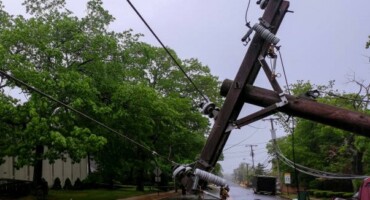
This follows a weekend of destructive storms that brought flooding, large hail, and damaging winds across parts of the capital, prompting renewed warnings for residents to remain alert as conditions remain highly unstable.
According to the SA Weather Services (SAWS), following the upgrade of a Severe Thunderstorm Warning (from Level 2 to Level 4) midafternoon on Sunday for Gauteng, Limpopo and Mpumalanga, significant weather impacts were recorded across the affected regions later that afternoon and in the evening.
“The earlier warning highlighted the potential for large hail, heavy downpours, and strong winds.
“All of the aforementioned impacts were realised as severe thunderstorms intensified over the northern parts of Gauteng (Pretoria) and adjacent districts of Limpopo (Marble Hall).”
Reports received from social media posts and weather observers confirm that the following occurred:
- Heavy rainfall that led to rapid flooding in low-lying and poorly drained areas.
- Damaging winds causing localised structural damage and the falling of trees.
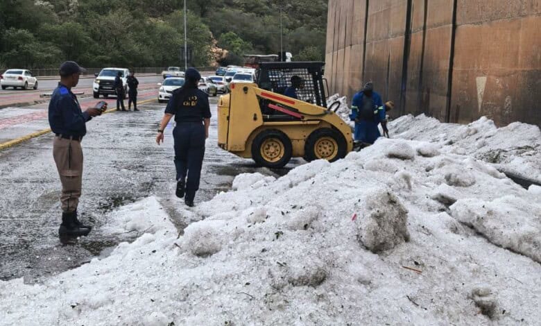
- Large hail, particularly over the East Rand (Brakpan, Benoni, Springs, Kempton Park, Thembisa, and Boksburg) and Pretoria North (Daspoort, Wonderboom, and Sinoville) resulting in vehicle, roof and property damage.
- Disruptions to traffic due to fallen trees, pooling of water as well as reduced visibility.
The SAWS said these impacts align directly with what is typically associated with severe thunderstorms characterised by strong convective updrafts and intense storm-cell organisation.
The severe weather developed within an environment of:
- High moisture availability over the eastern interior;
- Strong surface heating;
- Adequate wind shear; and
- A surface trough aligned with enhanced instability.
“These conditions supported the formation of deep convective storms capable of producing significant hail, damaging winds and heavy rainfall, validating the severity level (of the impact-based early warnings) communicated in the warning graphic.”
The SAWS urged the public to take weather warnings seriously, as they play a critical role in reducing the risk of injury, loss of life or property damage.
Yesterday’s impacts clearly demonstrate how quickly weather conditions can deteriorate once thunderstorms intensify.
Residents are encouraged to:
- Monitor updates from official sources;
- Seek shelter when thunderstorms approach;
- Move vehicles under cover where possible;
- Avoid driving through flooded roads; and
- Report fallen trees, flooding or damage to municipal authorities.
“Current climate trends and seasonal forecasts indicate a possible future increase in the frequency and intensity of extreme weather events across the eastern parts of South Africa, including Gauteng, Limpopo and Mpumalanga. This includes heavy rainfall and more frequent severe thunderstorms.”
Here are the predicted temperatures for the week in Pretoria:
- Monday🌥️13|23°C☂️60%
- Tuesday⛅️13|26°C☂️55%
- Wednesday⛅️14|24°C☂️49%
- Thursday🌥️13|23°C☂️48%
- Friday⛅️13|25°C☂️50%
Do you have more information about the story?
Please send us an email to [email protected] or phone us on 083 625 4114.
For free breaking and community news, visit Rekord’s websites: Rekord East
For more news and interesting articles, like Rekord on Facebook, follow us on Twitter