Snow expected – will Pretoria feel the chill?
Significant snow and heavy rain are expected in parts of the country from Thursday, but will Pretoria feel the chill?
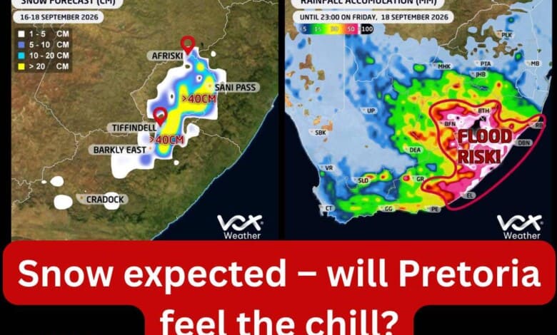
Heavy rain, possible flooding and significant snowfall are forecast for parts of South Africa from Thursday, but Pretoria is expected to escape the worst of the wintry conditions.
According to Vox Weather, a strong interaction between upper-air and surface weather systems is expected from Thursday into Friday.
The developing system could produce widespread rain and potentially significant rainfall over parts of the Eastern Cape, KwaZulu-Natal, Lesotho and the Free State.
Vox Weather said a steep upper-air trough approaching South Africa from the west would interact with a strong high-pressure system and a surface trough extending southwards from the tropics.
These systems are expected to draw substantial moisture into the eastern parts of the country, bringing widespread rain to the eastern coastline and neighbouring interior on Thursday.
Rainfall totals of between 30mm and 50mm in 24 hours are possible across several areas of the Eastern Cape, KwaZulu-Natal, Lesotho and the Free State.
Some weather models indicate that more than 50mm could fall locally along the Eastern Cape’s Wild Coast on Thursday alone.
According to Vox Weather, the upper-air trough is expected to intensify into a cut-off low over Namibia on Friday.
This could produce another round of scattered to widespread rain and thunderstorms over areas that may already have received substantial rainfall.
Another 30mm or more is possible over parts of the Free State, eastern Eastern Cape and southern KwaZulu-Natal.
Of particular concern is the Wild Coast, where the Global Forecast System model indicates that some areas could receive close to 100mm on Friday.
Vox Weather warned that parts of the Wild Coast, southern KwaZulu-Natal and adjacent inland areas could receive 100mm or more over the two days if the heavier projections materialise.
Such high rainfall totals over a short period could result in flash flooding, overflowing rivers and streams, and flooding in low-lying areas.
Significant snowfall is also expected over eastern Lesotho and the southern Drakensberg.
Vox Weather said current model guidance indicated that heavy accumulations were possible, with more than 40cm of snow forecast over some of the highest terrain.
The accumulating snow could make travelling difficult or dangerous in mountainous areas and affect some high-altitude routes.
Pretoria is not currently among the areas forecast to receive snow or the heaviest rainfall.
The South African Weather Service’s extended outlook indicates partly cloudy and cool-to-warm conditions, with isolated to scattered showers and thundershowers possible over parts of the country on Thursday and Friday.
Pretoria is expected to remain warm on Thursday, with the temperature reaching close to 30°C. A slight drop to the mid-20s is expected on Friday as the broader weather system develops.
Residents may therefore notice windier, cloudier and gradually cooler conditions, but the capital is unlikely to experience the icy temperatures forecast for Lesotho and the Drakensberg.
Vox Weather cautioned that the exact position of the heaviest rain and the final rainfall totals could still change as the system develops.
Residents and travellers have been advised to monitor official warnings, avoid flooded roads and low-water crossings, and exercise caution when travelling through affected areas.
Also read: Here is what we know about the eight murdered women
Do you have more information about the story?
Please send us an email to bennittb@rekord.co.za or phone us on 083 625 4114.
For free breaking and community news, visit Rekord’s websites: Rekord East
For more news and interesting articles, like Rekord on Facebook, follow us on Twitter or Instagram or TikTok or WhatsApp Channel.