GAUTENG DEPARTMENT OF ROADS AND TRANSPORT
Soweto Extension and Cosmo City Junction of the Gauteng Rapid Rail Integrated Network Extensions (approximately 72 km of new rail)
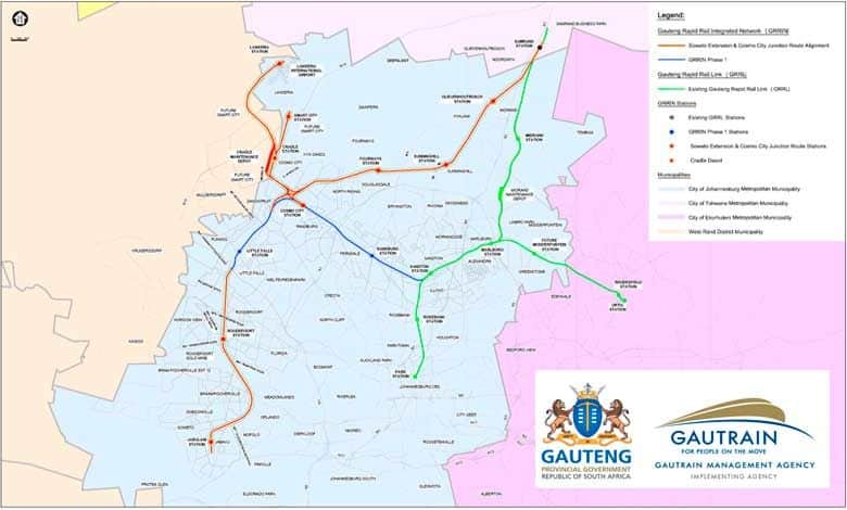
Notice is hereby given of the route determination of the provincial rail line for the Soweto Extension and Cosmo City Junction of the Gauteng Rapid Rail Integrated Network (GRRIN) Extensions Project (the Project) in terms of the Gauteng Transport and Infrastructure Act (No. 8 of 2001), amended by the Gauteng Transport and Infrastructure Act (No. 6 of 2003) (GTIA).
The following is a broad description of the route:-
Little Falls Station to Jabulani Station (Soweto) through Roodepoort Station:
The proposed route begins at the end of the GRRIN Phase 1 route near the M47 (Hendrik Potgieter Road), approximately 1.6 km South of Little Falls Station, and runs entirely underground for about 19.9 km to minimise surface disruption and environmental impacts. From Little Falls Station, the proposed route runs in a Southerly direction, passing under the suburbs of Helderkruin and Horizon View, before turning parallel to the PRASA line through to the proposed Roodepoort Station, where platforms are planned to remain underground while the station building is planned to be developed above-ground. From the proposed Roodepoort Station, the alignment deviates around Braamfischerville, parts of Meadowlands West and Dobsonville to avoid dolomite areas, passing under the R41 (Randfontein Rd), M77 (Dobsonville Road), and the Afrisam Roodepoort Plant, and crossing previously mined zones. The proposed tunnel route continues beneath Meadowlands East, Mofolo North, and Jabavu, intersecting the PRASA line at two locations before reaching the proposed Jabulani Station, which is similar to Roodepoort Station’s design with planned above-ground building and underground platforms.
Cosmo City Station to Lanseria Station through Cradle Station and Smart City Station:
The proposed route starts at the Cosmo City platform as defined by the GRRIN Phase 1 route and spans approximately 17.4 km entirely above-ground, with about 7 km on elevated bridge structures (viaducts). Beginning on an elevated section at Cosmo City Station, the planned route heads North-West through vacant land, crossing South Africa Drive through a planned overhead viaduct, turning in a Northly direction before running parallel with Marina Street, to service the Cradle Station. From the future Cradle Station, the proposed route continues in a North-Westerly direction, crossing over the R114 and N14 highway by viaduct. After the N14, the proposed route deviates slightly in a North-Westerly direction, crossing over Elandsdrift Road (viaduct), before curving Easterly toward Lanseria Airport. Finally, the proposed route crosses the R552 (Pelindaba Road) by viaduct, and terminates at the proposed Lanseria Station, located North of the existing Lanseria Airport parking area. The proposed Cradle Depot rail-spur is planned to be located parallel to Marina Street, crossing the R114 by means of viaduct, and connecting back into the proposed route before crossing the N14 (viaduct). The proposed Smart City route will tie into the proposed route leaving the Cradle Station and continue in a tunnel underground in a Northerly direction, cutting under the R114, R512 (Malibongwe Drive) and N14 before terminating at the proposed Smart City Station, where planned platforms will be developed underground while the station building is planned to be above-ground.
Cosmo City Station to Samrand Station through Fourways Station, Sunninghill Station and Olievenhoutbosch Station:
The proposed corridor starts at the Cosmo City platform as defined by the GRRIN Phase 1 route and spans approximately 30.4 km, mostly underground (about 25 km), with only 4.5 km near Cosmo City and 0.5 km near Samrand planned to be developed above-ground. Beginning above-ground at Cosmo City Station, the route heads North-West before turning North-East toward Fourways, crossing the R512 (Malibongwe Drive) by viaduct and entering a tunnel near Hoogland industrial area just before Witkoppen Road. The route then runs beneath Witkoppen Road to the proposed Fourways Station, where platforms are planned to remain underground while the station building is proposed to be developed above-ground. From the planned Fourways Station, the route continues North-East beneath Lonehill, the M71 (Main Road) and the M9 (Leeuwkop Road) to the proposed Sunninghill Station (where the platform is planned to be developed underground with station buildings planned to be above-ground). The route proceeds North-East underneath the suburbs of Waterfall, Kyalami Hills and Carlswald, passing under the R55 (Woodmead Drive), M39 (Allandale Road), and Walton Avenue/New Road to the proposed Olievenhoutbosch Station, where platforms are planned to be developed underground and station buildings planned to be constructed above-ground. The proposed tunnel-route then runs North-East, beneath Noordwyk and Randjespark, crossing under Eighth Road, Lever Road, Olifantsfontein Road, and the DBSA site, continuing to cross under the N1 and R101, and passes below the existing Gautrain Rapid Rail Link system before emerging above-ground at the future Samrand Station.
Notice is also given that the regulatory measures contemplated in Section 7 of the GTIA will take effect on publication of the route in terms of Section 6 (11) of the GTIA. These measures include that every application for the establishment of a township, for subdivision of land, for any change of land use in terms of any law or town planning scheme as well as for any authorisation contemplated in the Environment Conservation Act, 1989 (Act No. 73 of 1989) (ECA) or the National Environmental Management Act, 1998 (Act No. 107 of 1998) (NEMA) in respect of the areas mentioned in Section 8 (1) of the Act, must be accompanied by a written report by a consulting civil engineering firm specialising in road/ rail design and transportation engineering, reporting on the matters set out in that section. These measures appear from that section which is quoted below for reference:
“7. Regulatory measures in respect of routes
- After the publication of the notice contemplated in Section 6 (11) and in addition to any law, every application for the establishment of a township, for subdivision of land, for any change of land use in terms of any law or town planning scheme as well as for any authorisation contemplated in the ECA and NEMA, in respect of the areas mentioned in Section 8 (1), must be accompanied by a written report by a consulting civil engineering firm specialising in road design and transportation engineering, reporting on the following matters:
- The effect and impact which the granting of such application may have in respect of—
- The route contemplated in Section 6 (11);
- The future preliminary design of the provincial road or railway line in respect of which the said route has been determined; and
- The effect and impact which the granting of such application may have in respect of—
- Any other route published or deemed to have been published in terms of Section 6 (11), any preliminary design in respect of which the acceptance has been published or deemed to have been published in terms of Section 8 (7) and any other provincial road or railway line;
- The feasibility of amending the said route and the costs in respect thereof, should the application be granted;
- The additional cost in respect of future preliminary design if an amended route should be found to be feasible, should the application be granted; and
- Any other relevant matter pertaining to the said route, design and construction of the provincial road or railway line which may be relevant should the application be granted.
- The consulting civil engineering firm referred to in subsection (1) must be approved by the MEC as having members with the necessary specialisation and competence as contemplated in subsection (1) and with at least ten years’ experience in the required disciplines.
- The application accompanied by the report in addition to the provisions of any other law must be forwarded to the MEC by:
- The municipality; or
- The authority or body to which such application has been made; or
- The applicant, provided that the applicant must –
- Obtain the consent of the authorities mentioned in paragraph (a) or (b); and
- Submit proof to the satisfaction of the relevant authority that the applicant has forwarded the application to the MEC.
- The MEC may comment, in writing, on the application and accompanying report to the municipality, other authority or body to whom the application has been made, within a period of 60 days after having received the application and accompanying report, or such shorter period as may be prescribed in terms of any other law.
- No application may be granted without due consideration of—
- The comments submitted by the MEC;
- The written report and matters contemplated in subsection (1) above
- The additional costs which the granting of the application may cause directly and indirectly to the State and the community concerned, weighed against advantage to the applicant and the community of granting the application; and
- The extent to which the granting of the application promotes sustainable development which integrates transport planning and land use planning in view of transportation engineering requirements.
- After having made its decision on the application, the municipality or other authority must inform the MEC in writing of its decision within 14 days after having made such decision and in the event of the application having been granted, must furnish full reasons for such decision in writing to the MEC within the said period.
- Within 28 days after having received the decision and reasons for having granted the application, the MEC is entitled to appeal against the decision, in accordance with the procedure prescribed in the applicable law with the necessary changes being made, to the appeal authority or appeal tribunal provided for in the relevant law, provided that where the applicable law prescribes an appeal to the Premier, any member of the Executive Committee, or Government official of the Province, the appeal must be heard and finally disposed of by the Townships Board for the Province as though the said Townships Board had the final appellate jurisdiction with regard to the appeal.
- After the publication of the notice contemplated in section 6 (11) and despite any law to the contrary, no service provider may after commencement of this section, lay, construct, alter or add to any pipeline, electricity line or cable, telephone line or cable, or any other structure on, over or under the areas described in section 8 (1) or may construct, alter or add to any structure of any nature whatsoever on, over or under such areas, except—
- If the written permission of the MEC has been obtained and only in terms of such conditions as the MEC may prescribe; or
- In terms of an existing registered servitude.”
The route determination is applicable from the date of this notice.
The route determination report is available at the Office of the Gautrain Management Agency; 44 Grand Central Boulevard, Grand Central, Midrand.
Electronic copies of the route determination report are available at www.gautengrapidrail.co.za.
In terms of Section 6 (11) (c) of the GTIA, interested and affected parties may also request reasons for the decision of the MEC with respect to the determination of the route within 30 days of the date of publication of the notice. Interested and affected parties are invited to submit such request and any further enquiries regarding the determination of the Soweto Extension and Cosmo City Junction of the GRRIN Extensions Project by email to extensions@gautengrapidrail.co.za for the attention The Project Manager: Soweto Extension and Cosmo City Junction of the GRRIN Extensions Project, with the subject GRRIN/SECCJ.