Tent Travels: The emerald road alongside a lake of many moods
Stylish tourist amenities have really made the Eastern Shores route a winner.
CAPE Vidal hasn’t changed much since we first visited it many years ago, but getting there has become so much more fun. The drive from St Lucia to Cape Vidal, once a straight there-and-back route, much of it through sterile commercial plantations, used to be pretty boring. Now those exotic trees have had their marching orders as part of iSimangaliso Wetland Park’s rigorous rehabilitation of the Eastern Shore section of this wonderfully diverse park.
In fact some 12 000ha of alien plants and commercial forests within the park boundaries have now been cleared and this massive programme has absolutely transformed the eastern Shores section. Also, as part of the park’s massive rehabilitation projects, the wetlands in the Eastern Shores section have been wonderfully regenerated. These soggy places are so important to the health of the environment. They are nature’s sponges, storing the summer rain, stopping erosion by mopping up the run-off and then slowly releasing the moisture into the system as the rain dries up during winter.

The Eastern Shores wetlands and associated grassy plains, swampy forests, pans and lakes are just so beautiful and provide a very hospitable environment for all sorts of creatures, great and small. All this, plus the many new game viewing roads and loops, hides, viewing platforms and attractive picnic area make it a very tourist-friendly destination, an extremely productive game-viewing and birding area and a stunningly beautiful place to explore.
The day we were due to set up camp at Cape Vidal, we packed up our St Lucia camp at first light and were soon crossing through Bhangazi Gate, a short distance out of town, into the Eastern Shores section. Immediately, we were impressed by all the game-viewing and birding actions. With so much to see, we took our time often stopping to watch the various animals and birds or just to admire the views.
The first turning to our left took us off the main road and onto the pan loop, past the pretty Mboma Pan. This little loop then crossed the main road and became the Vlei Loop, taking in the KuNgunuza Lookout.

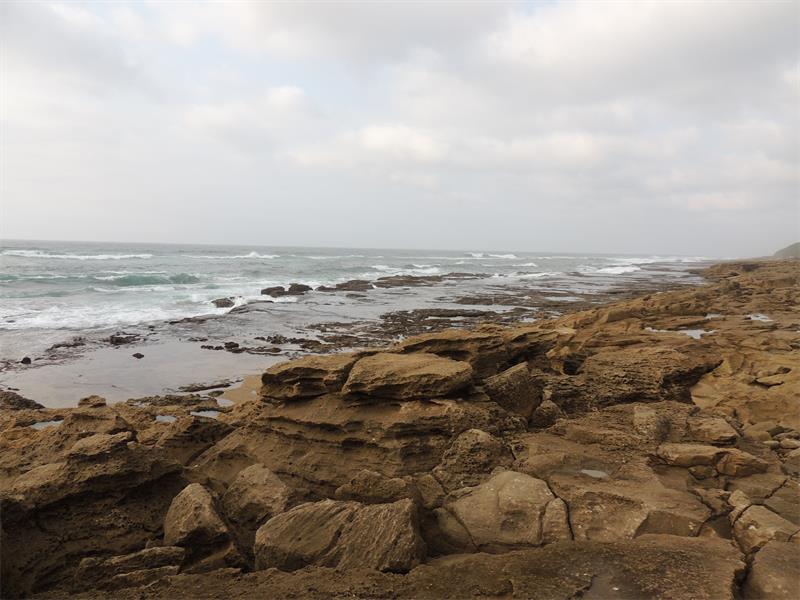
We were more than ready for breakfast by the time we reached Mission Rocks, where we had a choice of two sheltered, attractive and tree-shaded picnic sites. We did a little stroll to see the Mission Rocks, a ruggedly beautiful stretch of rocky shoreline, whose myriad rock pools invite exploration. After much consideration we chose the slightly more inland picnic site as it seemed more conducive to a little breakfast birding.
Back on the road we soon encountered a sort of African fairytale castle, an attractive, artistically designed, multi-levelled structure built out of sandbags and latte. It was the roomy new kuMfazana Hide, a really lovely amenity, perfectly suited for a comfortable birding and game viewing session , overlooking a substantial pan and wetland system. It was really a gorgeous spot and we lingered there for quite a while. A few years previously we had visited Cape Vidal and had been impressed by the newly rehabilitated Eastern Shores section. Now, on this trip, the attractive and well-designed hide was just one of many examples of the stylish tourist amenities that had made this section an even more impressive tourist attraction.

Generally, the revamping of iSimangaliso Wetland Park over the last couple of years has elevated it to a world class eco-destination. It is growing in popularity but I believe iSimangaliso is still undervalued and that it has the potential one day to rival Kruger National Park as South Africa’s premier wildlife tourist attraction. For us, though, the highlight of that day’s route was the substantial new viewing platform overlooking Catalina Bay, offering the finest possible views of Lake St Lucia. It really is such a beautiful body of water and we sat there for a long time watching all the waders, herons and other water birds at work and drinking in the stunning views.
Catalina Bay is also of historic interest and was so named because it was a base for the Catalina flying boats during the war. Established in 1942 the base was used by 262 Squadron as part of a patrol programme to hunt U-boats around our coastline. Another reminder of the military action in this area during the war is the old radar installation on the high Mount Tabor dune near Mission Rocks.

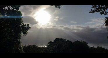
A final treat awaited us before we reach the camp at Cape Vidal. For most of the way the road had taken us over undulation grassy plains, interspersed with patches of swamp forests and dotted with glassy little pans. However, we veered off the main road again to do the Dune Loop, or what I call the Emerald Road, winding through the stunning dune forest. This 5km detour is a must if you are travelling this route.
During our three days in Cape Vidal we did a number of game drives in the Eastern Shores section but game wise, we found the Grasslands Loop the most productive. It once was a one way circular route that started near the Cape Vidal Camp and passed Lake Bhangazi, but because of a broken bridge it is now a there-and-back route starting at what was its exit point onto the main road, about 10km from Cape Vidal Camp. To your right, as you travel this road northwards, is a substantial swamp forest and the extensive Mfabeni Swamp. To the left are game rich grasslands, views of the lake and, in the region of the eZibomvini viewpoint, the strange red dunes.

On one of the very few rainy days we had during our KZN camping trip, we drove to Mission Rocks, optimistically with a breakfast picnic. It had rained rather heavily along the way but our optimism paid as the sun came out for a just long enough for us to enjoy breakfast in the pretty picnic site. Then the rain started again and the wind picked up and it was rather dark and stormy when we reached the Catalina Bay platform. The weather had scared off everyone else and we had it to ourselves. As pretty as the view had been on the last sunny day we’d been there we rather preferred this wild, wind-blown watery view of a lake of many moods.

DID YOU KNOW?
Click on the words highlighted in red to read more on this and related topics.
If you are reading this on your cellphone and there are telephone numbers provided in the text, you can call these simply by clicking on them.
To receive news links via BBM, add us using the pins 58F3D7A7 OR 58F25573. The South Coast Herald is also on Facebook, Twitter, WhatsApp and Instagram – why not join us there?