
Thousands ordered to evacuate as Typhoon Kajiki heads for Vietnam
Storm-battered Vietnam is mobilising ahead of Typhoon Kajiki, as authorities enforce strict safety measures and evacuations.
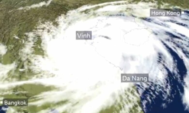
Typhoon Kajiki, the fifth severe storm to strike Vietnam this year, is forecast to make landfall this afternoon.
Authorities have issued alerts due to the storm’s high winds and steady strengthening, similar to Typhoon Yagi, which devastated the country just less than a year ago and was the strongest typhoon to hit northern Vietnam in 30 years.
BBC reports that Vietnam has ordered more than 586 000 people to be evacuated.
According to Vietnam’s National Centre for Hydrometeorological Forecasting (NCHF), Kajiki is expected to hit Thanh Hoa and Nghe An provinces, bringing winds of up to 166kph. Local authorities have imposed traffic restrictions in preparation for the typhoon’s arrival.
According to Vietnam Briefing, the eye of Kajiki was located 145km east of Ha Tinh province at 07:00 today. With maximum winds between 150 and 166kph, the storm has matched the intensity of Typhoon Yagi.
At the time of publishing, Kajiki was moving west-northwest at an average speed of 20kph.
Warm waters off Vietnam’s north-central coast, with temperatures reaching 30°C, have fuelled Kajiki’s rapid intensification. Its speed and favourable winds have further strengthened the storm, said Vietnam Briefing.
Over the past five hours, Kajiki has shifted slightly north. Although it remained about 200km offshore from Ha Tinh and 180km from northern Quang Tri earlier today, its 200km-radius wind field has already begun affecting north-central provinces.
The NCHF warns that Kajiki, which has maintained high intensity for roughly 30 hours, is expected to hit the coastal belt from Thanh Hoa to Quang Tri this afternoon. The typhoon will then move inland between Thanh Hoa and Nghe An before reaching central Laos by 04:00 tomorrow. Its slightly northerly trajectory means landfall will occur later than initially predicted.
More than 700mm of rain forecast
Regional meteorological agencies have reported strong winds along the coast. Japan’s meteorological agency notes increasing wind speeds, while Hong Kong forecasters report winds around 155kph, expected to remain consistent at landfall.
Heavy rainfall is forecast across the Red River Delta, including Hanoi, and provinces from Lao Cai to Hue, with totals of 100mm to 150mm over the next two days. Some areas, particularly from Thanh Hoa to northern Quang Tri, could see rainfall exceeding 700mm, posing a high risk of flash floods. Thunderstorms are also expected in Hanoi, Ho Chi Minh City and Da Nang.
Strong winds are predicted from Thanh Hoa to northern Quang Tri, reaching up to 166kph in some areas. Southern Thanh Hoa and Ha Tinh are likely to experience the most severe conditions, while moderate winds are expected further north, from Quang Ninh to Ninh Binh.
Vietnamese authorities have issued strict warnings, urging all maritime and coastal activities to remain suspended due to hazards such as vessel capsizing and structural damage along the shoreline.
Live: Typhoon Kajiki approaches the central coast of Vietnam #CGTNonsite https://t.co/nxOaIslfxo
— CGTN (@CGTNOfficial) August 25, 2025
Typhoon KAJIKI will shortly make landfall in northern Vietnam
Wind gusts in excess of 200km/h (125mph) are likely, with the risk of a 2-4m storm surge on the coast.
300-400m of rain is expected too with the risk of flooding and landslides.https://t.co/XcE1SiaPsP pic.twitter.com/MDOMLDMNjE
— BBC Weather (@bbcweather) August 25, 2025
UPDATE: Typhoon Kajiki
Typhoon Kajiki is expected to make landfall in Vietnam on Monday with possible winds of up to 180km/hr
The storm skirted past Hainan in China, where 320mm (12.6in ) of rain was forecast footage shows the extreme wind and rain in the area #typhoonkajiki pic.twitter.com/npxLhfYNnB
— Chyno News (@ChynoNews) August 24, 2025
Pictures taken on Monday morning show streets submerged in muddy water and trees lying toppled across roadways in the city of #Sanya in south China’s #Hainan Province, after Typhoon #Kajiki battered the island with fierce winds and torrential rains on Sunday.
According to the… pic.twitter.com/0ZGLDq9qRt
— CGTN (@CGTNOfficial) August 25, 2025
Typhoon Kajiki lashed South China with fierce winds and heavy rain, as Vietnam readied mass evacuations ahead of landfall. https://t.co/2Lc3Y87YpK pic.twitter.com/3zNEvPDgs6
— DW News (@dwnews) August 25, 2025
Breaking news at your fingertips… Follow Caxton Network News on Facebook and join our WhatsApp channel.
Nuus wat saakmaak. Volg Caxton Netwerk-nuus op Facebook en sluit aan by ons WhatsApp-kanaal.
Read original story on www.citizen.co.za