
Hail, thunder and more heavy rain expected to lash the North Coast
The 'extreme danger to life' cannot be overstated - fast flowing rivers, possible mudslides, landslides and soil erosion all pose an extreme risk with the upcoming weather.

North Coast residents and motorists are urged to take the latest weather warnings seriously, with up to 150mm of rain expected to fall between Thursday and Friday this week.
The South African Weather Service issued a severe weather watch alert today, warning of possible thunderstorms, hail and heavy rains for Thursday.
Further warnings included damaging winds and the possibility of flooding.
ALSO READ: WATCH: Four people reported missing after storm hits Ilembe
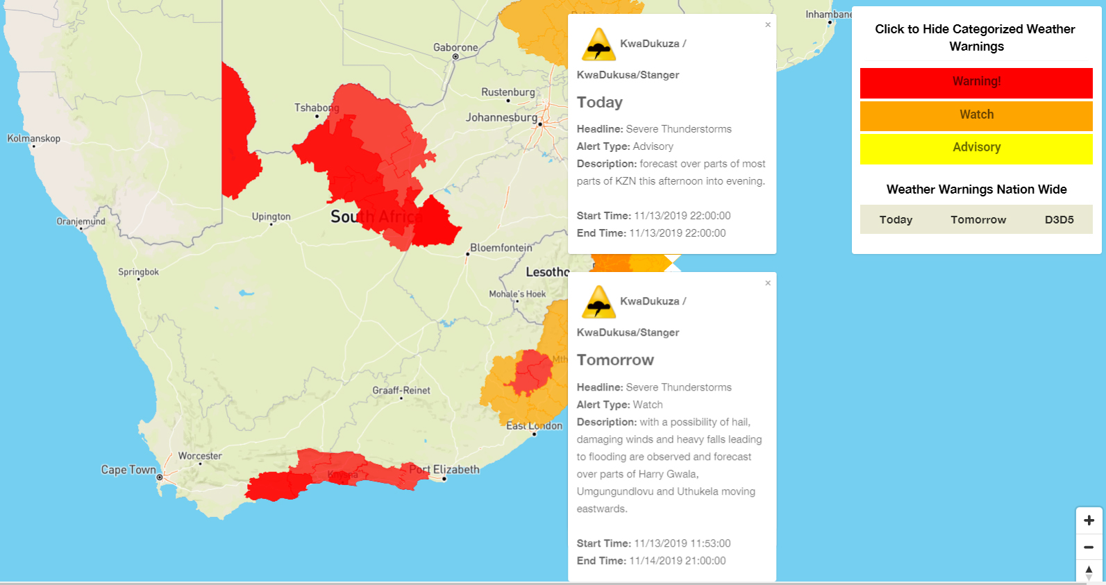
A map indicating today and tomorrow’s weather alerts.
A separate weather watch alert was also issued for a possible severe thunderstorm this afternoon (Wednesday).
WATCH:13/11/2019 13h00 TO:13/11/2019 00h00 Severe Thunderstorms- are possible over most of KZN from the afternoon (Wed). Please note that severe thunderstorms can produce a variety of elements. Warnings will be issued when these thunderstorms are conducive for these elements. pic.twitter.com/1RNOrSFSuR
— SA Weather Service (@SAWeatherServic) November 13, 2019
According to figures released by the SA Weather Service, rainfall over a 24-hour period set to lash the coast between Thursday and Friday may run between 100mm and 150mm, perhaps even more.
“Over the central and eastern parts of KwaZulu-Natal, this heavy rain is expected to lead to flooding of roads and settlements both formal and informal, which may result in some communities being displaced and inaccessible,” said the SA Weather Service.
The ‘extreme danger to life’ cannot be overstated – fast flowing rivers, possible mudslides, landslides and soil erosion all pose an extreme risk with the upcoming weather.
Further afield in the extreme eastern parts of Limpopo and Mpumalanga, a cut-off low pressure system slowly moving toward KwaZulu-Natal thoroughly soaked parts of the two provinces.
Welkome #reen sak uit in #Mokopane #Limpopo 📸 Arina Griesel @SAWeatherServic @sawx_sa_weather @eNCA @eNCAWeather @venter_annette @debeer_anika @JoelGuy_ @agri_limpopo @landbou @Netwerk24 @maroelamedia @TheSAnews @SABCNewsOnline @SABC_2 @sabcnuus @huisgenoot @zarsg pic.twitter.com/af3JL2EGli
— ReenvalSA (@ReenvalSA) November 12, 2019
The same low pressure system is expected to arrive in KwaZulu-Natal tomorrow (Thursday).
Meanwhile, following yesterday’s tornado in New Hanover, video footage of the damage has been shared on Twitter.
Did you take the video?
— Storm Report SA (@StormReportSA1) November 13, 2019
Download The North Coast Courier mobile app, now available free from the Apple iStore and on Google Play, for IOS and Android phones.

Stay in the loop with The North Coast Courier on Facebook, X, Instagram & YouTube for the latest news.
Mobile users can join our WhatsApp Broadcast Service here, or if you’re on desktop, scan the QR code below.