KZN Weather: Why April is the province’s most dangerous month
Discover why KZN faces 'explosive' storms in April. Experts explain science behind recent Pietermaritzburg tornado and unstable weather.
RECENT heavy weather episodes across KwaZulu-Natal, coupled with ever-present memories of the 2022 floods, has residents questioning the cause of the province’s unstable weather.
According to the meteorologists running the Severe Weather and Information Centre South Africa (SwaicSA) Facebook page, the phenomenon of unstable weather in April is neither new nor likely to change.
ALSO READ: Above average winter rainfall expected for Zululand region
“April is a dangerous transition month over South Africa — especially for KZN,” said SwaicSA.
“Seasonal Shift Chaos Summer is fading, winter is approaching, and the atmosphere becomes unstable and unpredictable.
“Warm, moist air still lingers over KZN, while cooler systems begin pushing in from the south and west.”
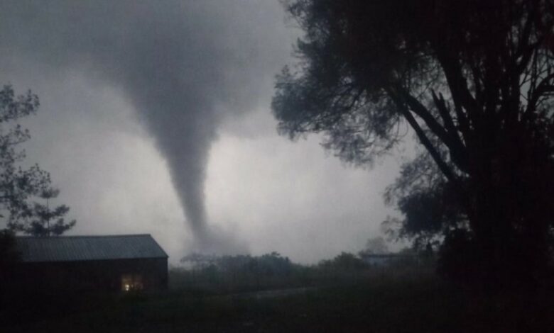
The explanatory post was prompted by a tornado that hit parts of Pietermaritzburg over the Easter weekend.
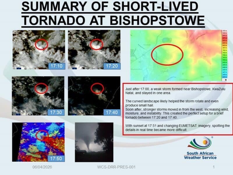
The South African Weather Service (SAWS) verified and confirmed the tornado, which struck the Bishopstowe area on the evening of Easter Sunday.
According to the SAWS, the cause was a weak storm that developed just after 5pm on the day in question.
Owing to unstable conditions and the local curved landscape, the storm intensified rapidly, causing rotation.
Significant damage was caused to electricity infrastructure, tearing down power lines and trees, and causing widespread power outages. Property in low-lying areas was also damaged.
According to SwaicSA, there are various meteorological phenomena that, when they collide, the result is ‘explosive’ thunderstorm development, sometimes rapidly intensifying into severe storms or even supercells.
ALSO READ: FMD vaccinations begin in Hlabisa and Mtubatuba
These phenomena include high humidity from the warm Indian Ocean, lingering heat and moisture, incoming upper-air disturbances and troughs, and cool air from the south and south-west.
“Fast development = limited warning. These storms can develop and intensify very quickly, sometimes within an hour,” said SwaicSA.
“That makes it extremely difficult for forecasting systems to issue timely warnings every time.
“History doesn’t lie; some of the worst floods and storm events in KZN’s history have occurred in April — this is not new, and it’s not random.
“This month is also the peak period for cut-off lows in South Africa — slow-moving, moisture-rich systems that can bring days of heavy rain, flooding, and widespread impacts.”
Don’t have the ZO app? Download it to your Android or Apple device here:


HAVE YOUR SAY
Like our Facebook page and follow us on Twitter.
For news straight to your phone invite us:
WhatsApp – 060 784 2695
Instagram – zululand_observer
TikTok – @zululand_observer