
November snow dusts Sani Pass as spring cold snap hits
Mountain peaks along the Lesotho border woke up to a white blanket, but forecasters say the freezing conditions will not grip inland provinces.
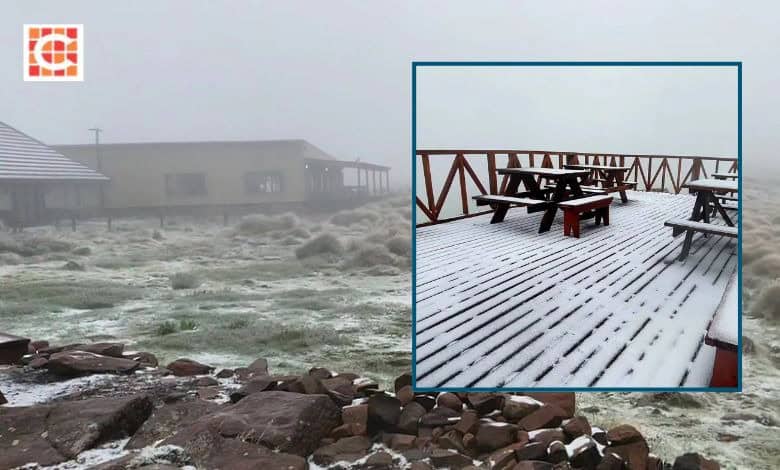
A late-spring dusting of snow transformed the southern Drakensberg over the weekend, turning the summit of Sani Pass white yesterday (November 8).
Sani Mountain Escape, situated at Sani Top on the rim of the Lesotho escarpment, confirmed the snowfall on social media, noting that a light layer settled across their viewing deck, rooftops and mountain grasses beneath thick mist. Lodge management advised visitors that alpine weather shifts rapidly and urged motorists to verify official Sani Pass road conditions before heading up.
Traveller Philip Rawlins, visiting Sani Top on a guided 4×4 excursion with Motsamai Tours, also documented the conditions online, describing an overnight stay in the ‘cold wet Sani Top’ with unseasonal ‘snow in November’.
The chilly system was felt beyond the escarpment into the KZN Midlands. Posting to the Severe Weather and Information Centre SA group this morning (November 9), Barbara-Ann Robertson shared a photo of the pass, remarking: “Light dusting of snow Sani Pass. No wonder Howick felt so cold yesterday.”

The snowfall aligned with weekend European Centre for Medium-Range Weather Forecasts guidance, which had predicted potential snow over Lesotho’s highest peak, Thabana Ntlenyana, and neighbouring high-altitude terrain.
Inland forecast shows no severe chill for Gauteng
While snow pictures circulated widely on social media, the weather system responsible for the mountain freeze will not plunge the northern provinces into winter.
Pretoria experienced midday thundershowers and cooler conditions yesterday, with daytime temperatures dropping to 24°C today, as reported by Pretoria Rekord. However, current meteorological outlooks show the capital and surrounding inland regions quickly returning to warm conditions rather than experiencing a prolonged cold snap.
According to the official South African Weather Service (SAWS) travellers’ forecast for tomorrow (November 10), mild to warm weather will dominate the major centres:
- Pretoria: Partly cloudy, min 11°C, max 29°C
- Johannesburg: Partly cloudy, min 13°C, max 28°C
- Vereeniging: Partly cloudy, min 10°C, max 28°C
- Pietermaritzburg: Morning fog patches, otherwise fine, min 10°C, max 29°C
- Durban: Fine, min 16°C, max 25°C
- Bloemfontein: Fine, min 11°C, max 35°C
Rather than cold weather warnings, SAWS issued advisories for very hot conditions with maximums reaching 36°C to 40°C in the Namakwa District and interior Western Cape, alongside extremely high fire danger warnings across parts of the Free State, North West, Northern Cape, and Western Cape.
At Sani Pass, the snow will remain short-lived. AccuWeather’s Sani Pass forecast indicates that skies will clear and temperatures will rebound into mild afternoon highs over the coming days.
Travellers planning trips across high-altitude mountain routes in Lesotho and the Drakensberg are advised to monitor updated road and weather reports before travelling.
Breaking news at your fingertips… Follow Caxton Network News on Facebook and join our WhatsApp channel.
Nuus wat saakmaak. Volg Caxton Netwerk-nuus op Facebook en sluit aan by ons WhatsApp-kanaal.
Read original story on www.citizen.co.za

