Photos: Snow confirmed in parts of SA
Snow hunters, it’s happening! The first snowflakes landed in parts of South Africa this morning.

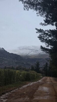
Snow fell across several regions of South Africa this morning as a powerful winter storm moves across the country, confirming forecasts of one of the most widespread snow events in years.
Pretoria Rekord reports that snow blanketed high-lying areas of the Western Cape, Northern Cape, Eastern Cape and Lesotho on this morning, as temperatures plunged and eager snow chasers flooded social media with photos of the winter spectacle.
The heaviest snow is still to come — with over 50cm expected in places like Barkly East and Afri Ski by tomorrow.
Vox Weather’s Michelle du Plessis says the system will intensify as it develops into a cut-off low, dragging freezing levels lower and setting the stage for heavy snow over mountain ranges, including the Drakensberg, Southern Lesotho and parts of KZN, where the deepest accumulations are expected.
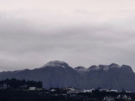
With social media buzzing among snow hunters eager to see the snow, forecasters warn that travel conditions could become hazardous, especially on mountain passes and rural roads.
Authorities urge South Africans to prepare for widespread frost, strong winds and icy conditions today and into next week, and to closely monitor updates as forecasts continue to evolve.
Here is where you will find snow:
In the Western Cape:
- Matroosberg
- Cederberg
- Swartberg
In the Northern Cape:
- Nuweveld and Roggeveld mountain, including Sutherland
- Great Karoo
High-lying areas in Cape provinces:
- Around Fraserburg
- Loxton
- Murraysburg
- Richmond
- Noupoort
- Colesberg
- Burgersdorp
- Aliwal North
- Molteno and surrounds
Lesotho could experience snow depths exceeding 50cm tomorrow, particularly around Afri Ski, and the Eastern Cape may expect between 50cm of snow over the southern Drakensberg and nearby towns, including Barkly East.
A mixture of snow/ice, rain and sleet is possible over the southern and eastern Free State:
- Bethlehem
- Warden
- Heilbron
- Reitz
- Memel
- Reddersburg
- Trompsburg and surrounding towns
This includes the north-eastern parts of the Northern Cape, around Postmasburg and Kuruman.
Meanwhile, the South African Weather Service has issued a Yellow Level 1 warning for damaging coastal winds from Saldanha Bay to Cape Agulhas, and icy road conditions are expected across several interior districts, especially around Beaufort West.
With snowfall already likely over Lesotho and nearby areas today, and heavier falls predicted through next week, South Africans are advised to monitor updates closely and prepare for travel disruptions, icy roads and sudden temperature drops.
Breaking news at your fingertips… Follow Caxton Network News on Facebook and join our WhatsApp channel.
Nuus wat saakmaak. Volg Caxton Netwerk-nuus op Facebook en sluit aan by ons WhatsApp-kanaal.
Read original story on www.citizen.co.za