Unexpected hailstorm hits Randfontein
A senior weather forecaster at SAWS said they didn't get any kind of warning on their satellite systems and didn't foresee anything extreme like a hailstorm being imminent.
The South African Weather Service (SAWS) said the hailstorm that hit Randfontein on Tuesday May 17 was an unusual weather incident and completely unforeseen.
According to Puseletso Mofokeng, a senior weather forecaster at SAWS, they didn’t get any kind of warning on their satellite systems and didn’t foresee anything extreme like a hailstorm being imminent.
We’re saying it was unusual because a low pressure system was sitting in die upper air over the North West for most of the time, but we did see cloud movement from north to south,” Mofokeng said.
When the wind reached the northern side of Randfontein in the valley, it started to spin. “Because of the persistent flow of the wind in that valley it was able to generated some small hail which was accelerated by the speed of the wind. Considering the season, it was easy for the ice particles to form as the clouds became stationary,” Mofokeng said.
“We’ve also seen some images of damaged carports and some cars being completely covered in hail,” Mofokeng said.
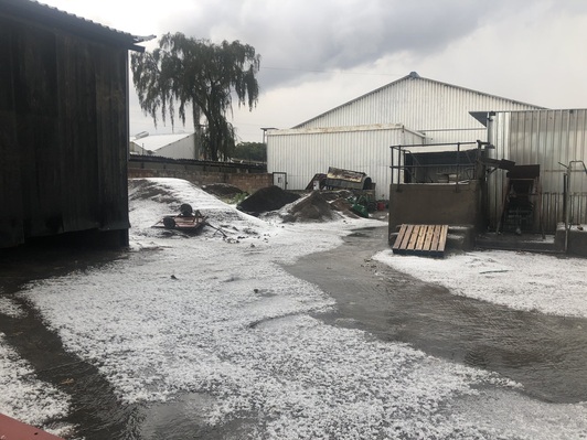
#Hael vandag in #Westergloor, #Randfontein.
📷Erika Lyth @SAWeatherServic @VoxWeatherZa @peoples_weather @ewnreporter @maroelamedia pic.twitter.com/luYlMECrp7— ReenvalSA (@ReenvalSA) May 17, 2022
U guys and ur sister @SAWeatherServic are reporting on something that had already happened, didnt U forsee this? Why was there no warnings of at least a a storm? #Randfontein https://t.co/73a7qAsiJl
— Domkop Ye Genius 🇿🇦 (@DonaldQuadratic) May 17, 2022
Hail storm that just hit #Randfontein @RfonteinHerald looks like snow pic.twitter.com/AozsVYFMYL
— Chantelle Idle (@I_Chanty) May 17, 2022