Brace for bitter cold: Snow now possible for these parts of Gauteng
A major cold blast is on the way, and these parts of Gauteng could even see snow. Here's the latest forecast.
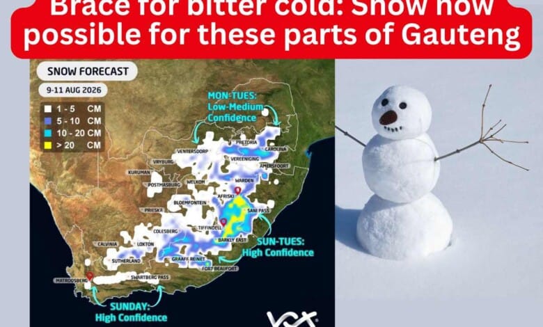
Residents across Gauteng are being urged to prepare for a significant cold snap next week, with the latest forecast from Vox Weather indicating that snow is once again possible in parts of the province.
According to Michelle du Plessis of Vox Weather, more than one forecast model is now suggesting that a powerful winter system moving across South Africa from Sunday, August 9, could bring a mixture of rain and snow to parts of Gauteng and the Highveld by Monday and Tuesday.
However, she stressed that the forecast remains several days away and that there is still considerable uncertainty.
“The exact rainfall and snowfall areas will depend heavily on the position, movement and strength of the cut-off low. Even a small shift in the system could completely change where the heaviest rain and snow occur,” Du Plessis said.
For now, she said more than one weather model is indicating the possibility of snow over Gauteng, but it is still too early to confirm exactly where it will fall, how heavy it could be or whether it will settle.
The winter system will begin with a strong cold front reaching the south-western parts of the country on Sunday, bringing widespread rain, strong winds and snow to the mountains of the Western Cape before spreading eastwards.
By Monday, a cut-off low-pressure system is expected to develop behind the cold front, resulting in widespread showers and thunderstorms across the southern and eastern parts of the country.
As freezing levels fall, forecast models indicate a mixture of rain and snow could develop across parts of the Free State, North West, the Highveld and Gauteng.
The higher-lying parts of Gauteng currently stand the best chance of seeing snowflakes if temperatures drop low enough, although any snow that falls is likely to be mixed with rain. This means it may melt on contact and not settle on the ground or blanket the landscape in white.
According to Vox Weather, the latest ECMWF forecast model also continues to indicate the possibility of further snowfall over parts of Gauteng, Mpumalanga, the northern Free State, Lesotho and the southern Drakensberg on Tuesday, August 11.
The forecast also points to disruptive rainfall over parts of Gauteng, Limpopo and Mpumalanga, with more than 50mm of rain possible in some areas within 24 hours.
Du Plessis said confidence in a major cold outbreak is increasing, even though the exact snow forecast remains uncertain.
“We will continue tracking the system and provide updates as confidence improves. One thing is still certain: a major cold blast is on the way,” she said.
Also read: Electrocuted at Planet Fitness: Pretoria man finally discharged after month in hospital
Do you have more information about the story?
Please send us an email to bennittb@rekord.co.za or phone us on 083 625 4114.
For free breaking and community news, visit Rekord’s websites: Rekord East
For more news and interesting articles, like Rekord on Facebook, follow us on Twitter or Instagram or TikTok or WhatsApp Channel.