Everything you need to know about last weekend’s gale force winds
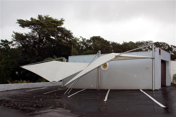
During the height of the storm wind speeds gusted up to 120km per hour.
NO it wasn’t a relative of Hurricane Irma or a cyclone, typhoon or even a tornado that wreaked havoc on the South Coast and much of the rest of the province on Saturday last week.
YOU MIGHT ALSO BE INTERESTED IN: Gale force winds wreak havoc – South Coast Herald roof ripped off
According to Margate Airport it was simply gale force winds caused by a low pressure zone moving up the coast. Whatever its classification the wind was strong enough to leave plenty of damage in its wake and even to take a life.
At the height of the storm a pedestrian, Sicelio Sithole (66) was killed by flying debris in the Magog area.
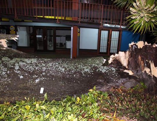
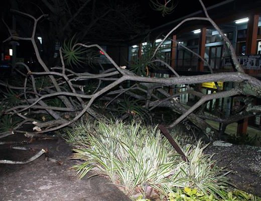
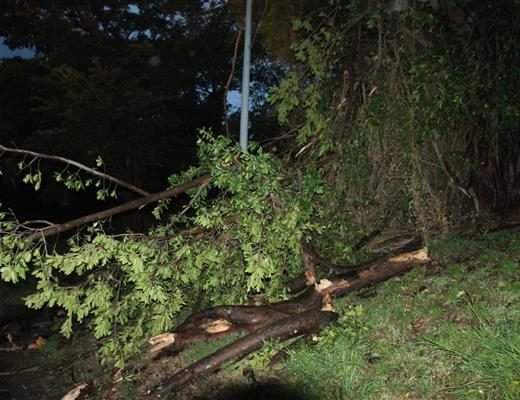
Intermittent heavy rain added to the problems, hampering clearing up operations for most of the weekend and on Monday this week. Emergency personnel between Port Edward in the south and Ballito in the north are still dealing with the substantial storm damage.
In the Ray Nkonyeni Municipality six dwellings had been totally destroyed and a further 11 had been damaged. Homes and commercial properties had been left without roofs, walls had collapsed and the Gamalakhe police station had lost a balcony, said municipal spokesman Simon April.
Many roads and driveways throughout the municipal area had been blocked and property had been damaged by fallen branches and uprooted trees, he added. In a number of areas residents experienced power and water outages during the storm.
A Margate Airport official said the South Coast had been battered by winds of about 50 knots or 92km per hour, occasionally gusting up to 65 knots or 120km per hour. Any wind with a speed of 40 knots or more was classified as a gale, he said.
Mr April said municipal rainfall figures showed that about 64mm of rain had fallen between September 16 and 18. The weather station at Outlook Farm in Southbroom measured 16mm on Friday last week, 5,5mm on Saturday, 12,5mm on Sunday and 0.6mm on Monday.
Many people are puzzled about the differences between hurricanes, tropical cyclones and typhoons. According to the National Geographic website, these are one and the same thing.
Different terms for these fierce storms are used in different parts of the world.
However, Weather SA points out that tropical cyclones and tornadoes are very different phenomena. A tropical cyclone is an intensely developed low-pressure cell that usually occurs over warm oceans. Its diameter can range between 200 and 2 000 km and it can last for a few days. The tropical cyclone season in our part of the world is from November to April.
Tropical cyclones moving into the Mozambique channel influence South Africa’s weather, but only a few move in close enough to the land to cause destructive winds and floods in Limpopo, Mpumalanga and KwaZulu-Natal provinces. Among the most troublesome for South Africa were Domoina, in January 1984, Imboa in February 1984 and more recently Eline in February 2000.
A tornado, sometimes known as a twister, is a violent rotating column of air that extends from a thunderstorm and is much smaller in diameter, typically less than a few hundred metres, but some are larger than 1 km. They usually occur over land, are generally short lived and can be on the ground for a few seconds to minutes. If a tornado occurs over water is called a water spout.
YOU MIGHT ALSO BE INTERESTED IN: Tornadoes: Nature’s hardest weather event to predict
Tornadoes can occur where thunderstorms are possible and have been experienced in Gauteng, the Free State, KwaZulu-Natal (along a line from Pietermaritzburg to Ladysmith) and the northern region of the former Transkei. Most inflict only light damage on the area through which they move.
Weather SA has explains some other weather-related phenomena the South Coast experiences, including the so-called berg winds that often warm up our winter days. These are hot, dry winds blowing off the interior plateau of South Africa, roughly at right angles to the coast, when there is a low-pressure system present along the coast and a high-pressure system over the continent.
The cold fronts bring us winter chills, wind, cloudy weather, rain and the good winter surf much anticipated by local surfers. They occur where a large mass of advancing cold air undercuts the warmer air pushing it upwards. Cumulonimbus clouds form a well-defined line along the boundary between the air masses and air temperatures may become noticeably cooler.
HAVE YOUR SAY
Like the South Coast Herald’s Facebook page, follow us on Twitter and Instagram
For news straight to your phone, add us on BBM 58F3D7A7 or WhatsApp 082 421 6033