Video: Landspout spotted between Middelburg and Belfast
Mother nature shows her power and beauty.
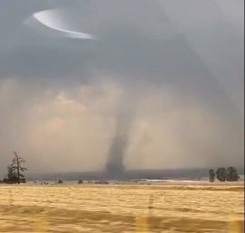
A striking weather phenomenon that looked like a tornado was spotted from the N4 between Middelburg and Belfast earlier today.
The rare sight, captured on video by Mareta le Roux, shows what appears to be a landspout, a type of tornado that forms differently from the classic tornadoes seen in the United States.
@middelburgobserver A landspout spotted from the N4 between Middelburg and Belfast has caused a stir across South Africa! Captured by Mareta le Roux and shared on Reënval in SA, the video has gone viral nationwide. Landspout, Middelburg, Belfast, SAWeather, ViralVideo, MiddelburgObserver
Former journalist Matthew Handley did some research on the phenomenon.
According to the American National Severe Storms Laboratory (NSSL), a landspout is a ‘non-supercell tornado’. Unlike the classic tornado, which forms from a rotating thunderstorm, a landspout develops while the thunderstorm cloud is still growing, with its spinning motion originating near the ground. NSSL describes it as a narrow, rope-like condensation funnel connecting the ground to the developing cloud above.
While generally weaker than classic tornadoes, landspouts can still cause significant damage. According to NSSL and The Weather Channel, they can produce wind damage consistent with EF2 or EF3 intensity on the Enhanced Fujita scale:
EF3 (Severe Damage): Entire storeys of well-built houses destroyed; severe damage to large buildings such as shopping centres; trains overturned; trees debarked; heavy cars lifted and thrown; structures with weak foundations blown away.
EF2 (Considerable Damage): Roofs torn off well-constructed houses; mobile homes destroyed; large trees snapped or uprooted; light debris turned into missiles; cars lifted off the ground.
Definition source: The Weather Channel.
