Ex-cyclone Dineo has SA disaster management teams on high alert
Along with damaging strong winds, heavy rains and possible flooding is expected in Limpopo, Mpumalanga and North-eastern parts of KwaZulu-Natal.
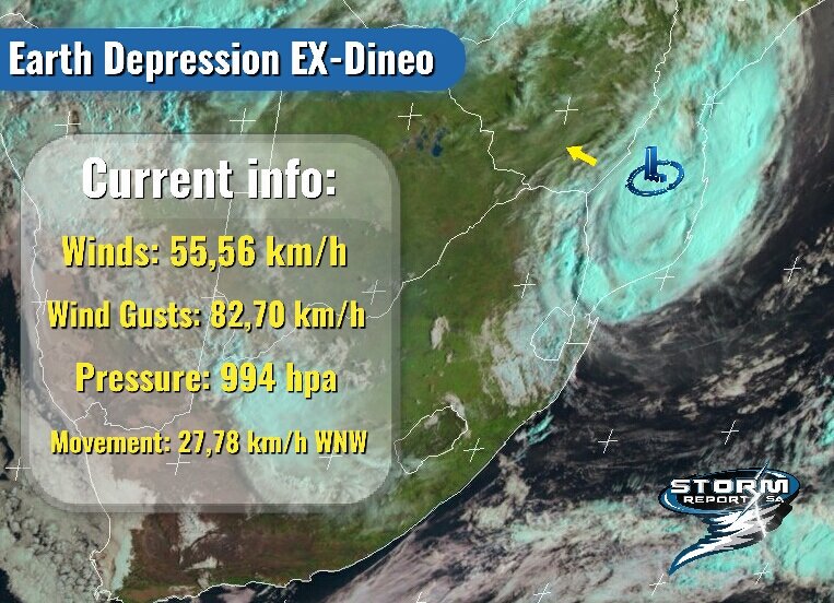
NEWCASTLE – The South African Weather Service (SAWS) released a statement regarding ex-cyclone, Dineo who made landfall near Southern Mozambique last night. (Wednesday, February 15).
They said strong winds, exceeding 100km/hr as well as torrential rainfall and very rough seas were most likely the main weather-related impacts.
“Satellite-derived estimates of overnight rainfall strongly suggest that at least 100 to 200mm of rain or more occurred overnight, along the coast and adjacent interior.”
With disaster management teams on high alert, numerous warnings and safety precautions have since been taken.
Office
– Make sure all equipment is switched off and unplugged
– Close and lock all windows and doors in the office
– Avoid working after hours due to challenges you may face when the storm hits.
– Make your colleagues aware of your whereabouts, and how they can contact you.
Home
– Ensure all equipment is switched off and unplugged especially during a storm
– Make sure all windows and doors are closed and locked
– Postpone planned trips, travels or outings and always know the whereabouts of your loved ones
– Do not attempt to make open fires, use handigas or candles. Rather keep torches and warm clothing handy.
– Emergency numbers to call, Police- 10111, 034 314 6158/9, 034 314 6235 Fire Department- 034 328 4700.
Must read stories on the site:
- ALERT: Cyclone Dineo set to strike South Africa tomorrow
- Severe storm causes widespread flooding and major damage
- How Dineo will affect SA
- WARNING: Suspected tropical disturbance to hit the coast of SA this week
- VIDEOS: Tropical storm Dineo uproots trees, roofs in Mozambique
Remember to visit our Facebook, Twitter and Instagram pages. You can also email our offices on reveshni@caxton.co.za
Add us on WhatsApp today! 082 874 5550

and BBM pin D1EF333B.