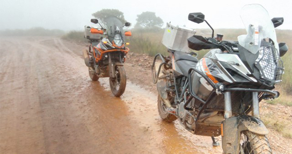
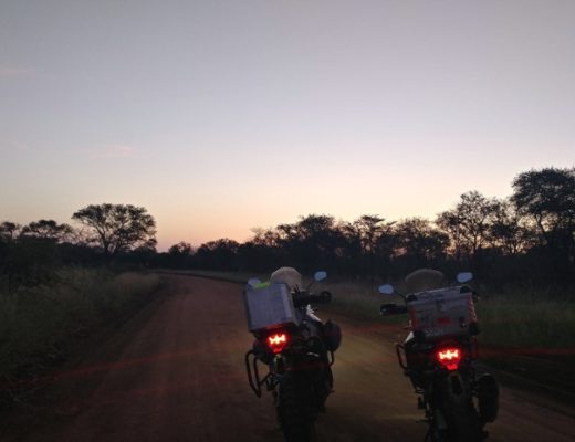
Lowveld highland roads wet and muddy
Our route started off on the N4 through the Schoemanskloof Road that was completed in 1928. This almost 100-year-old road rides like a dream.

We are surrounded by awesomeness from all sides! Dullstroom, for example, is an awesome place with an incredible history. As one of the coldest towns in Mpumalanga, it is one of South Africa’s premier fly-fishing destinations.
Dullstroom was proclaimed a town in 1892 by Paul Kruger.
In 1893 it consisted of 48 people, eight houses, three stables, 10 cattle kraals and the “Boeren Handelsvereniging” trading store. When the British solders occupied the village in May 1900, during the Anglo-Boer War, they virtually razed it to the ground. Thankfully, Dullstroom was rebuilt.
Our route started off on the N4 through the Schoemanskloof Road that was completed in 1928. This almost 100-year-old road rides like a dream. We enjoyed the winding stretch of asphalt. It seemed like a day of riding in perfect sunny conditions. Knee-scraping turns led us to our first turnoff. Turn right at 25°34’37.9″S, 30°17’41.2″E and immediately turn left again.
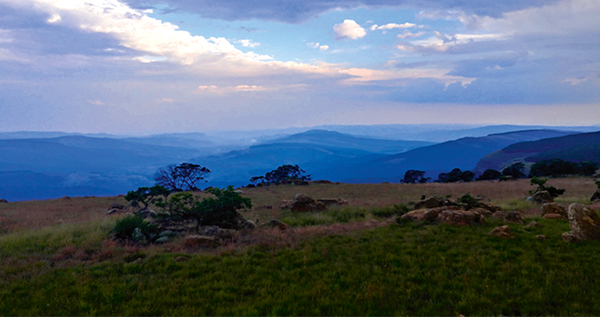
This old dirt road to Dullstroom meanders between farms and country lodges. The grassy fields and cool wind of the higher Lowveld welcomed us. We adored the landscapes with dams, hills, antelope and cattle.
At the intersection at 25°34’51.0″S, 30°09’22.3″E, continue straight or turn right. Both roads will lead to the R540 where Dullstroom is to the right. These old gravel roads connect eNtokozweni (Machadodorp), Dullstroom and the Schoemanskloof Road.
We reached the R540 and turned right onto the tar road. A light drizzle met us and accompanied us to cold Dullstroom.It suddenly felt like we were in an exotic cold place. We scurried to find good food and warm drinks.
Our taste buds were at a palate carnival enjoying the rides from good steaks to gourmet milkshakes to home-made fudge. It was a feast!
Dullstroom has the highest AMSL train station in South Africa, and it is well worth visiting. The largest clock shop in the Southern Hemisphere is also situated here.
The concept of The Clock Shop originated from the very first Finders Keepers by the Sunday Times newspaper in the year 1990. The first million rand was hidden behind a clock in the pub of the Dullstroom Inn.
We didn’t come to here just to eat and shop though. It was time to shake off a bit of the sugar and spice. No better way to do so than hitting a few dirt roads.
The staggeringly beautiful, narrow gravel roads of Dullstroom are exceptional. Steep climbs, deep ascents, and great views await the adventurers.
Gravel roads of Dullstroom/Kruisfontein
Turn right onto the dirt road at 25°23’49.1″S, 30°07’33.7″E. This large gravel trail is a perfect warm-up. The red road cuts through green grassy landscapes. There is a T-intersection at 25°22’46.6″S, 30°13’36.7″E. Turn left and enjoy the colourful dress that Mother Earth shows off.
De Berg
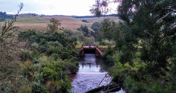
This light brown path takes you to a different world. It passes Nederhorst Train Station and leads you through the Verloren Vallei Nature Reserve with its breathtaking views. Continue left at the intersection 25°15’52.6″S 30°09’46.0″E and follow the road to the R577 tar road, turn right onto the tar for about 9,4km. This tar road that leads to 25°07’54.3″S 30°14’40.3″E, turn left towards Sekhukhune and continue 7,4km until you reach the Oshoek turnoff.
Other gravel options
Oshoek 25°04’40.1″S, 30°13’15.2″E
The Oshoek Road has one of the largest trees I have ever seen in Mpumalanga.
This route also passes a mine and a primary school. It leads to the intersection at 25°09’40.4″S, 30°10’32.2″E, where you turn left onto the Boschfontein Road, continue straight onto the Vermont Road.
Vermont 25°10’38.8″S, 30°11’49.4″E
We decided that, should we have children, they would be named after small villages around Hermanus and Gansbaai. Well, our first son would be named Vermont. This is a very scenic road that put a nice fat puncture in my rear wheel.
Take the dirt road, turn right after 700m and left after 1,7km. the Vermont Road is just 10km long.
Mashishing/Lydenburg
The town of Lydenburg was founded in 1850 by the company of Voortrekker leader Andries Potgieter who had abandoned their first settlement – Ohrigstad. Lydenburg, which means “place of suffering” was founded by these pioneering Voortrekkers fleeing malaria and the debilitating heat of the lower-lying areas.
Mashishing is what the place was traditionally called in Northern Sotho, meaning “long, green grass in the wind”.
The R540 takes you to Lydenburg. This road brings clarity to the news article I read, “the Lowveld, Potholes and Pancakes – Mpumalanga”.
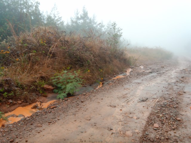
Across the road from the T-junction is a gravel road (25°06’52.6″S, 30°26’49.1″E), continue onto that road. The day we rode this beaut, a white curtain hung from the clouds to the foot of the mountain, a curtain of rain… We rode into that burst of cloud on the red-brown path that filled up with mud and streams.
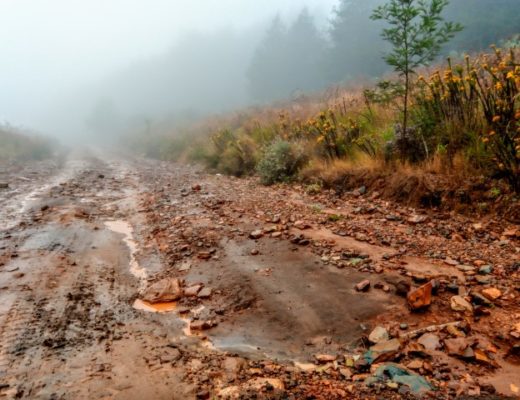
This red-brown road slips through the Makobulaan Nature Reserve. This reserve is a well-kept secret and paradise! The road has slight ascents and descents and reaches a beautiful viewpoint towards the left. It passes buildings almost as old as time itself.
The route then descends down into the Wonderkloof Nature Reserve. This road was part of the original Johannesburg/Mbombela road.
This road gives us a taste of what we probably never experienced in our lifetime. Imagine driving it with a vehicle without technology, ancient suspension, no power steering, no electronics and probably a car full of children! I looked down at my handsome KTM steed and realised how lucky we are to live now.
I didn’t hear any children cry from the old leather backseat. I just heard my engine cry for more adventure.
This road passes many old buildings that are hidden away from the public’s eye. In this forest many proud houses are hidden away, whether they are still standing or not. Forgotten lodges have been taken back by the forest that once nestled them.
The gravel turns into tar and passes the Sudwala caves, a must-visit. It was thought that the caves may have been used by President Paul Kruger to store the legendary “Kruger Millions”, gold bullion which reputedly disappeared somewhere between Waterval Onder and Mbombela during Paul Kruger’s flight from Pretoria to Lourenço Marques (now Maputo) in Mozambique (Wikipedia).
We arrived at home, wet from our helmets to the socks in our boots. The rain could not wash the smiles off our faces though.
We kept on talking about the route and continuously said, “This was one of the best days of my life!” Make every day count. Ride, live, be adventurous. And if life kicks sand in your face, rip it up with your rear wheel!