Severe thunderstorm alert in effect for Polokwane until tonight
After a wet start, more rain and localised storms are expected across Polokwane as the SA Weather Service issues a Level 2 severe thunderstorm warning.
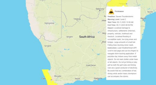
POLOKWANE – The South African Weather Service (SAWS) has issued a Level 2 severe thunderstorm warning for Polokwane, in effect from 10:00 this morning until 21:59 tonight.
The alert follows a morning of steady rainfall across the city, which left roads wet and visibility low.
According to Vox Weather, a high area of convergence will bring high instability value over the eastern escarpment, bringing a band of thunderstorms with it.
The SAWS says residents can expect localised damage to infrastructure, informal settlements, property, vehicles, and livestock, as well as flooding in low-lying areas, bridges, and susceptible roads.
They also cautioned that large amounts of small hail and falling trees could lead to temporary road blockages.
Residents are urged to remain cautious, particularly when driving on slippery or flooded roads.
Weather outlook
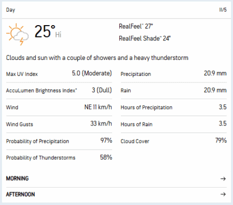
AccuWeather’s forecast suggests that a couple of showers and a heavy thunderstorm during the day, with a 25% chance of rain tonight.
Temperatures are expected to peak at around 25°C before dropping to 16°C overnight.
Rain and scattered thundershowers are also expected to continue into Thursday, with conditions likely to remain cool and cloudy for the rest of the week.
Read more: Mild week ahead for Polokwane with rain expected
Emergency services have advised residents to stay indoors during heavy storms, avoid crossing flooded roads, and secure outdoor items that could be damaged by strong winds or hail.