
Tropical Cyclone Freddy still too far from South Africa to predict path
The South African Weather Service said that tropical marine systems such as Freddy weaken significantly once they move overland.
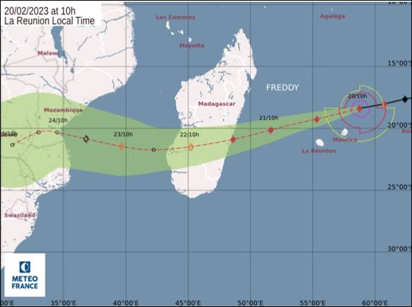
The South African Weather Service (SAWS) stated there is a small possibility of Tropical Cyclone Freddy affecting eastern Zimbabwe and the north-eastern sector of Limpopo later this week.
The SAWS released a statement this afternoon, February 20, emphasising that accurate and timely predictions of a tropical cyclone movement is associated with high levels of uncertainty.
Classified by the SAWS as an intense tropical cyclone, Freddy currently lies about 400km to the north-east of Mauritius and is expected to pass relatively close to the islands of Mauritius and La Réunion as it continues to drift further westwards. “Freddy is a relatively compact but nevertheless intense system, with a central pressure estimated to be 939hPa [hectopascal] and average winds of approximately 200km/h.”
ALSO READ: Vehicle hijacked in Rustenburg recovered in Mpumalanga
The weather service said, however, that the maximum wind gusts associated with this system are likely to be significantly stronger, estimated to be about 285km/h. “Interestingly, given the compact structure of Freddy, the most extreme winds will only be experienced within a 200km radius of the system.
In accordance with the latest track forecast for the cyclone, issued by the World Meteorological Organisation’s designated Regional Specialised Meteorological Centre (RSMC) located on La Réunion, Freddy is expected to continue along a predominantly west-south-westward track in the coming days. It is expected to make landfall along the east coast of Madagascar on Tuesday evening, February 21.
“While there is some degree of uncertainty regarding the exact location of the Madagascan landfall, according to RSMC La Réunion, it will probably be between the coastal towns of Mahonoro and Mananjary.”
The SAWS said that during the latter half of this coming week, Freddy’s remnants will continue to swirl over the southern half of Madagascar. “It is useful and relevant to keep in mind that tropical marine systems such as Freddy weaken significantly once they move overland. Such weakening is due to two physical processes. Firstly, the system is deprived of its primary source of energy, namely the release of latent heat in the moist lower atmosphere, overlying a warm ocean surface. Secondly, such systems typically encounter significant friction when interacting with a land surface. Therefore, once Freddy makes landfall over Madagascar, the intensity of the system, both in terms of central pressure and wind circulation, will lessen significantly.”
ALSO READ: R536 between Hazyview and Sabie permanently closed
The service said a potentially dangerous and uncertain phase during Freddy’s life cycle will occur later on Wednesday February 22 and into the early hours of Thursday, when the system is expected to slide out into the very warm ocean waters of the southern Mozambican Channel.
Currently, sea surface temperatures in this part of the channel are between 28°C and 29°C and will almost certainly lead to Freddy reintensifying. Freddy’s intensity and movement, as well as the system’s later possible landfall somewhere along the coast of Mozambique, is highly uncertain. “Notwithstanding the above, the current official, highest confidence track from RSMC La Réunion suggests Freddy might make landfall this Friday afternoon, February 24, near Beira, a large port city roughly midway along the Mozambican coastline.
“Thereafter, there is a possibility, albeit small, that Freddy might move inland, possibly affecting eastern Zimbabwe and perhaps including the north-eastern sector of Limpopo.”
ALSO READ: Man arrested in Barberton for shooting at police in chase
SAWS said in the event of the latter scenario, even Freddy’s weakened, dissipating remnants would still have the capacity to deliver significantly heavy rainfall, as well as the possibility of extensive flooding. “In the light of the recent, unrelated flooding event that affected Limpopo and Mpumalanga last week, any renewed flooding over these regions could potentially be catastrophic.
“The public can rest assured that the SAWS, in consultation with national and provincial disaster management structures, will continue to monitor developments on a 24/7 basis and will issue regular updates in this regard, across a variety of media and social media platforms.”
Updated information will regularly be available on www.weathersa.co.za, as well as on the SAWS’s Twitter account, @SAWeatherServic.