From trade routes to wagon roads: Chapter 3
This is the third in a series on the history of our region, the Onderberg.
What is known as the Onderberg area also includes places like Louisville, Schoemansdal, Buffelspruit, KaMhlushwa and, closer to the eSwatini border, places like Masibekela and KaMaqhekeza.
In the first article of this series, we focused on the original indigenous inhabitants of this region known to us and documented in history. In the second we looked at the first Europeans venturing into the area.
More than a century had now passed when the first white trader entered the area.
João Dos Santos Albasini was born on May 1, 1813, in Lisbon, Portugal. He came to Lourenço Marques in 1831 and became a trader and elephant hunter. The remains of his trading post can be found at the Phabeni Gate, 10 kilometres from Hazyview.
Lourenço Marques, now known as Maputo, was the starting point of many of the old trading routes that criss-crossed the countryside. When Albasini arrived in Lourenço Marques in the early 1800s, he set up his trading business, which included a network of trading routes that reached inland as far as the Lowveld. By 1845, he had established a trading post at Magashula’s Kraal (now known as Albasini Ruins). This trading post was positioned along two of these trade routes.
These trading routes were mere footpaths. It was with the inland movement of the first Voortrekkers seeking a wagon route to the coast that the first Europeans started to leave their marks in the Onderberg.
Forgotten Tracks and Trails of the Escarpment and the Lowveld, a recent publication by Gerrit Haarhoff, offers the most important research on the traces of all the important old wagon routes of this region – including the Onderberg:
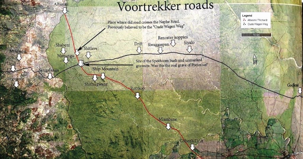
“Standing at the edge of the escarpment, we have to ponder the route the Trekkers would have taken. In 1844, a commission was sent forth by the Voortrekker leader, Hendrik Potgieter. At that stage there were no farms or any documented or European markers to trace the onward road with any degree of certainty.
“There are only a few salient points to consider:
“The commission would have avoided any potential swollen rivers, given the time of the year (summer) and their experience of the abortive trek in 1844. If they headed south-east, they would have had to cross both the Crocodile and the Nkomati rivers. Legogote was to their left (south) with a range of granite outcrops that would have made wagon travel impossible.
ALSO READ: Covid outbreak at Maartinshoop SAPS
“They would have taken the first available descending path, which was only about one kilometre from their vantage point. The descent at what was later called Burgershall is much further north, with difficult hills and the White Water River to cross in between.
“Albasini had not yet built his store at Magashula’s Kraal, and there would have been no reason for them to head towards Pretoriuskop. The slope on the south-eastern shoulder of Mathimba’s Kop was notoriously difficult, as described years later by an explorer, one Hampson, and would have been avoided.
“The road passing Pretoriuskop would only have come into existence after Albasini built his depot at Magashula’s Kraal in 1846. There would have been no reason for making this detour at the time of the ‘Oude Wagen Weg’.
“With this in mind, the most probable direction of the Oude Wagen Weg in the Kruger Park would be as follows:
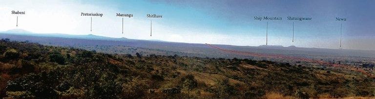
“After descending the last spur at Peebles, they crossed the North Sand River and headed east with Ship Mountain and Sithungwane as their waymarkers. Crossing the Nsikazi River at its upper reaches, close to Setigalanga’s Kraal, the road would have stayed south of Manungu Kop and headed in a direction between Ship Mountain to the south and Shitlave Hill to the north. The road continued on the northern side of the Mbiyamiti River, leaving only the drift at Siphampanane to cross.
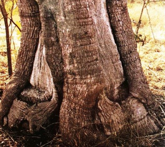
Once over it, the road headed due east towards Kwaggaspan, where Trichardt (this was Carolus Trichardt, the son of the first Voortrekker leader, Louis Trichardt, who had first entered this area six years previously in 1838; Carolus was now acting as guide) created a waymarker by chopping three deep gouges into the base of a leadwood tree (Combretum imberbe). “After 180 years, this can still be seen.
The road continued east and passed both the Renoster Koppies and Siyalokop to the south, heading towards the relatively easy incline of the Lebombo Mountains at Godleni Neck. Once across the Lebombo Mountains, they headed south-east and ended north of Pescene, facing the direction of Delagoa Bay.
The distance across the Lowveld to Delagoa Bay was 180 kilometres.
“It was immediately apparent that this road was unsuitable for wagon travel, because of the lack of perennial water as well as the tsetse fly danger. The commission lost all their cattle during this trip, and could only return with the help of Carolus Trichardt’s old friend, Albasini. The road was unpopular and fell into disuse after another commission was sent in 1848 to find a better route.”
Forgotten Tracks and Trails of the Escarpment and the Lowveld is available at the offices of Kruger Lowveld Tourism at Crossing in Mbombela or can be ordered at www.forgottentracks.co.za or info@forgottentracks.co.za.