Scattered-to-widespread showers and thundershowers are expected to continue until the weekend.

Picture: Jacques Nelles
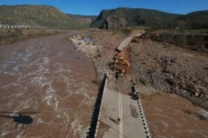
Various parts of the City of Tshwane are experiencing above average rainfall, which has result in increased water levels in rivers and dams, low water bridges and drainage systems in formal and informal settlements.
This comes after the South African Weather Service (SAWS) issued a yellow warning for disruptive rainfall across the country until Friday evening.
The city’s emergency services department also issued an alert to residents for destructive rainfall.
This week in Tshwane, two vehicles got trapped due to high water levels in Pretoria West. Fortunately, no injuries were experienced, said spokesperson Charles Mabaso.
ALSO READ: Eloise continues to bless SA’s dam levels
A house in Ramotse, Hamanskraal also reported flooding, while a roof at Masakhane Clinic collapsed.
Gauteng Today ‘s Weather overview: 29.1.2021 pic.twitter.com/HDYhHiVHzp
— SA Weather Service (@SAWeatherServic) January 29, 2021
Disaster Risk Management is currently conducting damage assessments in Zithobeni Extension 8 after various houses that were built in the wetland were flooded, he added.
The city has issued a warning over streets that have been identified as high-risk areas.
Residents have been warned to be careful on the Paul Kruger Street near the Wonderboom Pass, Vom Hagen Street, Centurion area (Rabie and End streets, Irene Bridge, Lenchen Road, West and Hall, and Centurion Lake).
Some roads and bridges have been closed and motorists are urged to use alternative routes.
“Keep safe following distances and drive at significantly reduced speeds during rain and wet road surfaces, find an alternative route and do not attempt to cross flooded bridges and streams. Channel water away from houses by digging furrows, making openings on the wall and placing sandbags to prevent water from coming into the house/yard.
ALSO READ: Disruptive rain, thunderstorms expected as Eloise returns to SA
“Cover valuables like furniture and move them to higher ground if possible. Switch off electrical appliances if the house gets flooded,” added Mabaso.
Though Eloise is now a weakened extra-tropical low-pressure system, it is expected to move to the Free State and North West, and the northeastern half of the Northern Cape this week.
Scattered-to-widespread showers and thundershowers are expected to continue until the weekend.
The rain will also usher in a cold front, said the SAWS.
For more news your way, download The Citizen’s app for iOS and Android.