Snow forecasted for Graskop on Thursday
Snow Report released in its latest forecast for the country, that they now have data indicating light snowfall as far as Graskop.
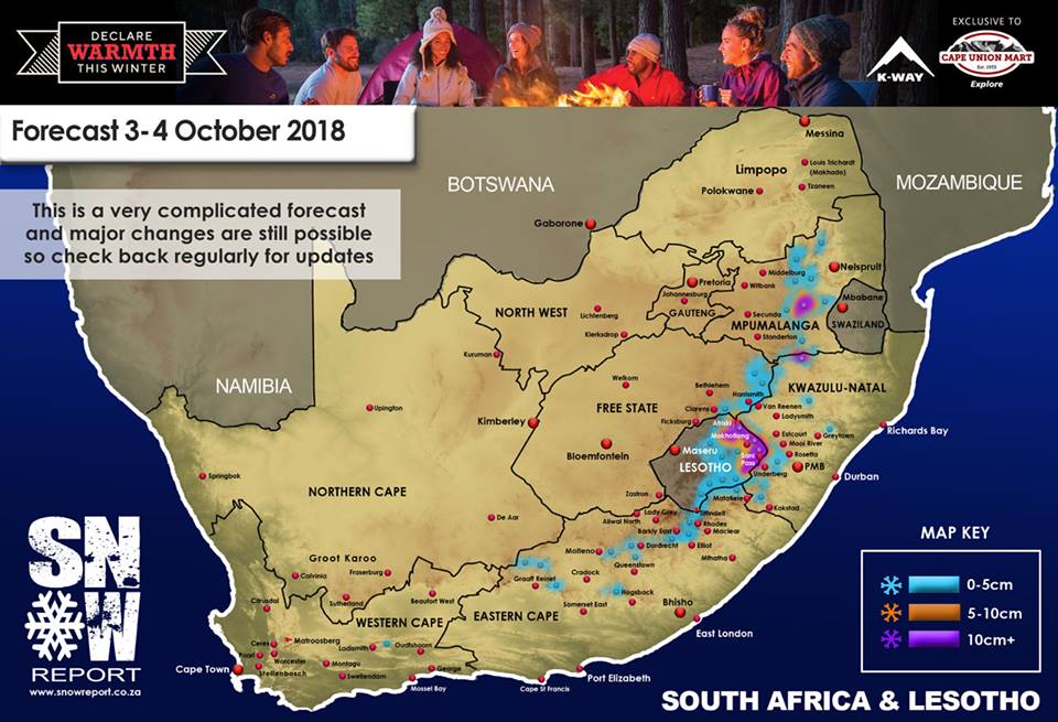
From the early hours of Wednesday morning they expect to see light snowfalls scattered around the Eastern Cape as per theirmap, and as the morning progresses, they are expecting to see snow starting to fall right the way along the Eastern Cape Drakensberg, the Southern Drakensberg and into the central high Drakensberg.
During the afternoon on Wednesday, they expect these falls to intensify in central eastern parts of Lesotho, as well as extending further north into the Maluti Mountains around AfriSki and between Clarens and Harrismith.
From late Wednesday night snowfalls over the Eastern Cape Drakensberg, the Southern KZN Drakensberg are expected, as well as the central and northern Drakensberg.
During this time, heavier falls are also expected in the central and eastern parts of Lesotho, and there is a chance that some lighter falls will happen in Matatielle area, and could also come down into the Underberg/Himeville area and the KZN Midlands areas.
During the early hours of Thursday morning, there is expected snowfalls showing for Mpumalanga and the far eastern Free State in a band from Harrismith in the south, to Graskop in the north, incorporating towns like Belfast, Ermelo, Wakkerstroom and Zamani, with flurries possible in neighbouring towns.
By late Thursday night all snowfalls should cease, with clear skies expected on Friday.