
Eloise changes tack – SAWS updates warnings
Eloise is expected to further intensify beyond its current status of “severe tropical storm” and obtain “tropical cyclone” status tomorrow.
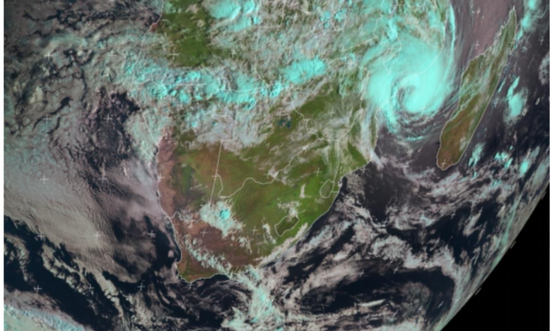
The South African Weather Service (SAWS) released an update today in which it said Eloise “has intensified significantly” in the past 24 hours, due to very warm ocean waters off the Mozambican Channel providing an abundant source of energy to drive the system.
SAWS said the system is expected to move ever closer to Beira, a coastal city in Mozambique, in the next 24 hours and that the area “can expect very destructive winds” reaching between 118 to 166 kilometres an hour.
The service said that given the clockwise rotation of surface winds around the system, and given the movement of the system, it expects the strongest destructive winds to hit the coastline immediately south of Beira.
ALSO READ: Eskom warns of higher electrical shock risks during Lowveld’s severe inclement storms
“Significant storm surges in and around the Beira coastline can also be expected in association with this system.”
SAWS added that following landfall of the storm, it expects Eloise to continue along a fairly straight path, taking it overland through southern Mozambique (as the system weakens) during the course of Sunday.
“It is at this time that the north-eastern parts of South Africa can anticipate the onset of heavy tropical rain, particularly along the escarpment and Lowveld areas of Limpopo and Mpumalanga, as well as the northern sector of Limpopo,” said the service.
“The northern parts of KwaZulu-Natal can also expect heavy rain during Sunday. These conditions are expected to continue into Monday.”
SAWS warned of a severe risk (orange, level nine) of disruptive rain with widespread flooding and flood-related damage of infrastructure, including housing, roads and bridges, in the aforementioned areas.
ALSO READ: KNP says its ready for possible Eloise repercussions
Although the heaviest rain is expected over Sunday and Monday, some rain is expected on Tuesday and Wednesday, too, albeit much lighter, which can result in further flooding as the ground would already be saturated.
SAWS added it expects strong surface winds circulating clockwise around Eloise will result in south-easterly to easterly gale-force winds of 35 to 40 knots (approaching 80 kilometres and hour), especially over northern Limpopo on Sunday.
A level four yellow warning of a significant risk of damaging winds has also been issued by SAWS.
These regions rarely experience such winds; consequently it can be expected that numerous trees could be toppled, while informal houses and structures may similarly be damaged.
ALSO READ: Disruptive rain expected for Lowveld, despite Cyclone Eloise changing track