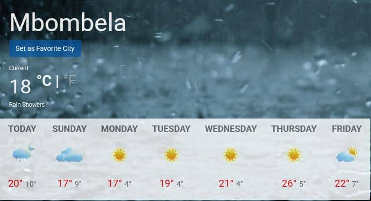
Brace yourself, Mbombela: The cold snap has arrived
The winter have a cold surprise in store for South Africa from tonight.

The SAWS issued a severe weather alert for the country from tonight, July 26.
A yellow level 2 warning with damaging wind and waves, which may result in localised disruptions to beachfront activities and difficulty in navigation, are in effect between Port Edward and Kosi Bay.
According to the SAWS, very cold conditions are expected over the north-eastern interior of the Eastern Cape.
Hey Mzansi!
Gauteng experienced its last snow July 2023, where were you?
Do you remember how cold it was in your area?
Which town or suburb did you observe it from?
Drop your photos, videos, or just your weather thoughts below!
video by https://t.co/N9rD40ZpSw #saws pic.twitter.com/4mts1rak0K— SA Weather Service (@SAWeatherServic) July 26, 2025
Here is your weather outlook heading into next week:
GAUTENG:
Partly cloudy and cool, with isolated showers and thundershowers.
MPUMALANGA & LIMPOPO:
Cloudy in the east with rain and showers in the morning. Otherwise, partly cloudy and cold to cool, with isolated showers and thundershowers in the afternoon.
⛈️Weather forecast for today & tomorrow, 26 – 27 July 2025.
Isolated to scattered showers & thundershowers are expected over the eastern & southern parts of the country, with possible damaging winds & waves along the east coast of RSA. #saws #weatheroutlook pic.twitter.com/MCaLyxxoxu— SA Weather Service (@SAWeatherServic) July 26, 2025
@lowvelder The SAWS predict bitter cold conditions for the country from tomorrow. A yellow level 2 warning was issued today, July 26, for severe thunderstorms for Limpopo and Mpumalanga from 16:00 ahead of the expected cold front. #saws #weatheroutlook #southafricanweather #rain #prediction #saws #mpumalangatiktoker #mpumalanga🇿🇦
♬ Weather forecast, morning, dawn, news, commercials(1483660) – KuromiJah
NORTH-WEST:
Fine and cold to cool, becoming partly cloudy in the extreme east, with isolated showers and thundershowers.
FREE STATE:
Morning fog patches in the east, otherwise fine and cold to very cold. Later, it will become partly cloudy in the extreme east with isolated showers and thundershowers.
NORTHERN CAPE:
Frosty in the southern interior at first, otherwise fine, windy, and cold to cool, but warm along the coastline. Winds along the coast will be strong southerly to south-easterly.
WESTERN CAPE:
Frosty areas in the interior in the morning, otherwise fine and warm. However, it will be partly cloudy and cold to cool in east and along the south coast, with light rainfall in the extreme south-eastern parts.
The wind along the coast will be fresh to strong southerly to south-easterly in the west and south-west, but light southerly in the south, becoming moderate easterly in the afternoon.
EASTERN CAPE:
In the western parts of the province, it will be cloudy and cold to very cold, with isolated showers and thundershowers in the south, becoming fine in the afternoon.
Coastal winds will be moderate southerly, becoming light to moderate south-easterly by late morning and moderate north-easterly by the evening.
In the eastern parts of the province, conditions will be cloudy and cold to very cold, with isolated showers and thundershowers along the coastline and adjacent interior, becoming partly cloudy in the evening.
Light snow is possible on the mountain tops in the south.
Wind along the coast will be fresh south-westerly, becoming light and variable in the south in the afternoon and spreading to the east in the evening. They will become moderate north-easterly in the south by the evening.
KWAZULU-NATAL:
Morning fog over the extreme north-western interior. Otherwise, cloudy and cool to cold, with isolated showers and thundershowers. Coastal winds will be moderate to fresh southerly to south-westerly, becoming light in the south by evening.
Yellow level 2 warning: Damaging winds
Affected area: KwaZulu-Natal
Validity period: 27 July 2025, 00:00 until 19:59 SAST#saws #weatheroutlook #southafricanweather pic.twitter.com/rVDXP3icBU— SA Weather Service (@SAWeatherServic) July 26, 2025
Stay warm!