
WATCH: Possible tornado forms near Dullstroom as severe storms hit Lowveld
Social media footage shows a dramatic cloud formation descending outside the Mpumalanga town while forecasters track active storm systems.
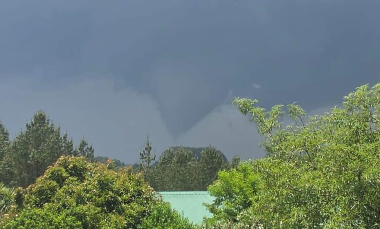
Social media pages Storm Report SA and The Weather Hooligan reported a potential tornado touchdown just outside Dullstroom around midday today.
Motorists and residents travelling through the area shared footage to the pages showing a severe weather formation with a visible cloud feature descending towards the ground, with some eyewitnesses online speculating the structure could be an F1 or F2 tornado.
An F1 tornado is a moderate tornado with wind speeds ranging from 117 to 180km/h while an F2 is a significant tornado on the Fujita scale with wind speeds ranging from 181 to 253km/h.
Weather authority confirms funnel cloud
The South African Weather Service (SAWS) confirmed that a funnel cloud formed near Dullstroom during the afternoon.
SAWS meteorologist Lehlohonolo Thobela said while SAWS has not officially classified the event as a tornado yet, a funnel cloud becomes a tornado once it makes direct contact with the ground surface.
ALSO READ: El Niño bring warmer, droër somer na Laeveld
The region remains under continuous monitoring by weather authorities as severe storm activity continues across that area. Residents and motorists are advised to stay updated with official SAWS alerts and exercise caution when travelling through storm-affected routes.
Weather conditions in Dullstroom at 13:35:
• Temperature: 25°C (High: 25°C / Low: 15°C)
• Condition: Mostly cloudy with light rain and afternoon/evening scattered thunderstorms
• Precipitation Chance: 17% to 35%
• Wind: North at 11km/h